IMAGES TAKEN NEAR TO
Bradley Road, BRISTOL, BS20 7TT
Introduction
This page details the photographs taken nearby to Bradley Road, BS20 7TT by members of the Geograph project.
The Geograph project started in 2005 with the aim of publishing, organising and preserving representative images for every square kilometre of Great Britain, Ireland and the Isle of Man.

There are currently over 7.5m images from over14,400 individuals and you can help contribute to the project by visiting https://www.geograph.org.uk
Image Map (9 Images)


Getting Data...Please wait
Leaflet Map data © OpenStreetMap
Images are licensed for reuse under creativecommons.org/licenses/by-sa/2.0
Notes
- Clicking on the map will re-center to the selected point.
- The higher the marker number, the further away the image location is from the centre of the postcode.
Image Listing (9 Images Found)
Images are licensed for reuse under creativecommons.org/licenses/by-sa/2.0
Image
Details
Distance
1
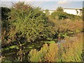
Drove Rhyne
From NCN26, with the southern fringe of the Royal Portbury Dock Industrial Estate on the other side.
Image: © Derek Harper
Taken: 30 Sep 2014
0.13 miles
2

Drove Rhyne
With NCN26 following bridleway LA15 21/20 on the right.
Image: © Derek Harper
Taken: 30 Sep 2014
0.14 miles
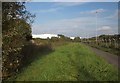
3

Bridleway by Royal Portbury Dock Road
With posts discouraging vehicles.
Image: © Derek Harper
Taken: 30 Sep 2014
0.14 miles
4
NCN26 by Drove Rhyne
With the Royal Portbury Dock Industrial Estate on the other side of the rhyne (left). Behind the fence on the right is one of many parking areas in the vicinity for new vehicles.
Image: © Derek Harper
Taken: 30 Sep 2014
0.16 miles
5
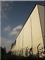
Cold store, Sheepway
In the angle between Royal Portbury Dock Road and Gordano Way, but seen here at its southwest corner from NCN26.
Image: © Derek Harper
Taken: 30 Sep 2014
0.19 miles
6
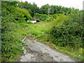
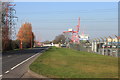
Shack next to the old Portishead railway line
The line is closed; this is a piece of waste ground north of the A369 near the M5 junction19.
Image: © Jonathan Billinger
Taken: 16 Jul 2009
0.20 miles
7
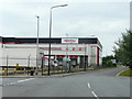
Bueno Apetito!
This factory at Portbury produces frozen ready-meals principally for local authority-run "meals on wheels" services.
It is German-owned.
Image: © Jonathan Billinger
Taken: 16 Jul 2009
0.20 miles
9
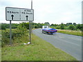
Approaching the M5 junction 19
Looking east on the A369 from Portishead.
Image: © Jonathan Billinger
Taken: 16 Jul 2009
0.25 miles