IMAGES TAKEN NEAR TO
Gordano Way, Royal Portbury Dock, BRISTOL, BS20 7SJ
Introduction
This page details the photographs taken nearby to Gordano Way, Royal Portbury Dock, BS20 7SJ by members of the Geograph project.
The Geograph project started in 2005 with the aim of publishing, organising and preserving representative images for every square kilometre of Great Britain, Ireland and the Isle of Man.

There are currently over 7.5m images from over14,400 individuals and you can help contribute to the project by visiting https://www.geograph.org.uk
Image Map (Loading...)


Getting Data...Please wait
Leaflet Map data © OpenStreetMap
Images are licensed for reuse under creativecommons.org/licenses/by-sa/2.0
Notes
- Clicking on the map will re-center to the selected point.
- The higher the marker number, the further away the image location is from the centre of the postcode.
Image Listing (4 Images Found)
Images are licensed for reuse under creativecommons.org/licenses/by-sa/2.0
Image
Details
Distance
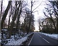
2
Portbury Lane
The sign on the left is unveiled when there is a risk of ice: Image
Image: © Roger Cornfoot
Taken: 26 Aug 2020
0.17 miles
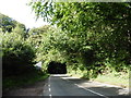
4
Ice Risk
This road sign seems a little ironic since the temperature was in excess of 27 degrees Celsius at the time. Near the top of Portbury Lane.
Image: © Steve Barnes
Taken: 28 Jun 2019
0.17 miles