IMAGES TAKEN NEAR TO
Rosemary Crescent, BRISTOL, BS20 7JT
Introduction
This page details the photographs taken nearby to Rosemary Crescent, BS20 7JT by members of the Geograph project.
The Geograph project started in 2005 with the aim of publishing, organising and preserving representative images for every square kilometre of Great Britain, Ireland and the Isle of Man.

There are currently over 7.5m images from over14,400 individuals and you can help contribute to the project by visiting https://www.geograph.org.uk
Image Map
Images are licensed for reuse under creativecommons.org/licenses/by-sa/2.0
Notes
- Clicking on the map will re-center to the selected point.
- The higher the marker number, the further away the image location is from the centre of the postcode.
Image Listing (10 Images Found)
Images are licensed for reuse under creativecommons.org/licenses/by-sa/2.0
Image
Details
Distance
1
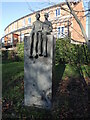
A couple sat on Phoenix Way
Part of the Portishead Art Trail, this piece is 'Precious' by London-based artist Carol Peace.
Image: © Neil Owen
Taken: 2 Jan 2023
0.14 miles
2

A precious pair
Carol Peace is noted for her sculptures of people in sedate, comforting poses. She was commissioned to create a piece for the Ashlands estate of Portishead's expansion, and this piece is called 'Precious'.
Image: © Neil Owen
Taken: 2 Jan 2023
0.14 miles
3
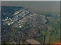
Portishead from the air
The business park and trading estate left of centre, and housing estates to the right, with the pier at the top.
Image: © Derek Harper
Taken: 22 Apr 2017
0.14 miles
4
Portishead Ecology Park
The ecology park was established in 2007 as part of the Port Marine housing development, creating a public open space and a flood storage buffer. Prior to that, the land was primarily grazing marsh and was artificially drained by a series of interconnected drainage ditches. The wetland habitat is made up of ponds, scrapes and marshy grassland. It is home to a range of wildlife species including nesting birds, reptiles, amphibians, small mammals, invertebrates and native wild flowers.
Image: © David Dixon
Taken: 18 Jul 2021
0.19 miles
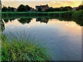
6
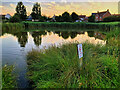
Pond at Portishead Ecology Park
The ecology park was established in 2007 as part of the Port Marine housing development, creating a public open space and a flood storage buffer. Prior to that, the land was primarily grazing marsh and was artificially drained by a series of interconnected drainage ditches. The wetland habitat is made up of ponds, scrapes and marshy grassland. It is home to a range of wildlife species including nesting birds, reptiles, amphibians, small mammals, invertebrates and native wild flowers.
Image: © David Dixon
Taken: 18 Jul 2021
0.19 miles
7

Modern town-houses
These two town-houses form part of a short terrace on Tydeman Road near to its junction with Galingale Way.
Image: © Ruth Riddle
Taken: 10 Jul 2012
0.19 miles
8
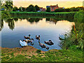
Swan Lake, Portishead Ecology Park
The ecology park was established in 2007 as part of the Port Marine housing development, creating a public open space and a flood storage buffer. Prior to that, the land was primarily grazing marsh and was artificially drained by a series of interconnected drainage ditches. The wetland habitat is made up of ponds, scrapes and marshy grassland. It is home to a range of wildlife species including nesting birds, reptiles, amphibians, small mammals, invertebrates and native wild flowers.
Image: © David Dixon
Taken: 18 Jul 2021
0.20 miles
9

Marina Healthcare Centre
Part of the new expansion of Portishead has brought N.H.S. services to the town.
Image: © Neil Owen
Taken: 2 Jan 2023
0.24 miles
10
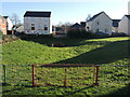
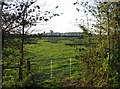
Balancing pond in Paper Mill Gardens
With Portishead's flat and marshy hinterland now occupied by housing, the estate has a balancing pond to cope with excessive rainfall and flooding. However, it lies next to a children's play area, and has an electricity substation opposite. See Image] for the play space.
Image: © Neil Owen
Taken: 2 Jan 2023
0.25 miles