IMAGES TAKEN NEAR TO
Woodhill Road, BRISTOL, BS20 7ET
Introduction
This page details the photographs taken nearby to Woodhill Road, BS20 7ET by members of the Geograph project.
The Geograph project started in 2005 with the aim of publishing, organising and preserving representative images for every square kilometre of Great Britain, Ireland and the Isle of Man.

There are currently over 7.5m images from over14,400 individuals and you can help contribute to the project by visiting https://www.geograph.org.uk
Image Map (Loading...)


Getting Data...Please wait
Leaflet Map data © OpenStreetMap
Images are licensed for reuse under creativecommons.org/licenses/by-sa/2.0
Notes
- Clicking on the map will re-center to the selected point.
- The higher the marker number, the further away the image location is from the centre of the postcode.
Image Listing (139 Images Found)
Images are licensed for reuse under creativecommons.org/licenses/by-sa/2.0
Image
Details
Distance
1
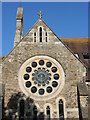
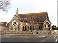
East window of the old church
The former Union Congregational church was built in 1877 and has particularly ornate appearance for a relatively small sect. The east window is a prime feature.
Image: © Neil Owen
Taken: 14 Jul 2024
0.03 miles
2
Architecture Congregational
Ancient Architecture of the Congregational gone URC. This is a key junction and landmark. Man on roof with ladders laid across this slope repaired it not so long ago.
Image: © MDS
Taken: 26 Feb 2007
0.04 miles
3
The lodge and the old Congregational church
Church-goers in Portishead were forming a Congregation from the 1830s and slowly built a church on West Hill. That became insufficient and a new church was needed; this site on Woodhill Road (now Cabstand/Nore Road) was chosen, right next to the existing lodge (left of shot).
Architects Wills and Voisey of Bristol were appointed, as was talented builder Mr W. Bennett, and they created the large and impressive Union Congregational church we see today. The foundation stone was laid on 9th December, 1875 and the church cost £3,344.
Sadly the costs of running the church and a dwindling congregation forced the authorities to sell it in 2010. It was converted into residential use.
Image: © Neil Owen
Taken: 14 Jul 2024
0.04 miles
4
Former Church - Portishead
This Church has now been converted into a number of apartments - hence the solar panels and the dormer windows.
Image: © Steve Barnes
Taken: 6 Apr 2015
0.04 miles
6
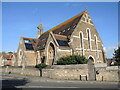
A view of the old Congregational
A large and impressive church was built at the top of Cabstand in 1887. It served the Union Congregational movement until it was part of the United Reformed Church, finally closing its doors in 2012 and becoming a residential property.
Note the many solar panels and the open top of the roofspace over the circular window.
Image: © Neil Owen
Taken: 26 Oct 2022
0.04 miles
7
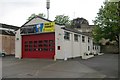
Portishead Fire Station
Portishead Fire Station, Station Road, Portishead, Bristol is station numver 07 of Avon Fire & Rescue Service
Image: © Kevin Hale
Taken: 8 May 2006
0.06 miles
8
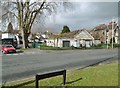
Portishead, scout hut
On Station Road. https://www.portishead-scouts.org/
Image: © Mike Faherty
Taken: 16 Mar 2018
0.07 miles
9
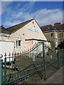
Portishead Scouts' hall
The First Group meet here. Their logo is set into the gates.
Image: © Neil Owen
Taken: 25 Feb 2022
0.07 miles
10
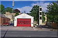
Portishead Fire Station and drill tower, Station Road, Portishead, Somerset
Opened in 1973 and operated by Avon Fire & Rescue Service. The station is manned by retained firefighters and has two water tenders. Although the address is Station Road, unfortunately there is no longer a railway serving the town but there are plans progressing for its restoration as part of the Greater Bristol Metro scheme.
Image: © P L Chadwick
Taken: 9 Jun 2013
0.07 miles