IMAGES TAKEN NEAR TO
Harbour Road, BRISTOL, BS20 7AN
Introduction
This page details the photographs taken nearby to Harbour Road, BS20 7AN by members of the Geograph project.
The Geograph project started in 2005 with the aim of publishing, organising and preserving representative images for every square kilometre of Great Britain, Ireland and the Isle of Man.

There are currently over 7.5m images from over14,400 individuals and you can help contribute to the project by visiting https://www.geograph.org.uk
Image Map
Images are licensed for reuse under creativecommons.org/licenses/by-sa/2.0
Notes
- Clicking on the map will re-center to the selected point.
- The higher the marker number, the further away the image location is from the centre of the postcode.
Image Listing (72 Images Found)
Images are licensed for reuse under creativecommons.org/licenses/by-sa/2.0
Image
Details
Distance
1
British Rail
Another View from the Interflow bridge zone, the opposite way, south of Port Marine, Portishead. Development, with a rail bridge to the right, or is it Conservation Ecology? Whatever, it is mostly waste beneath, over silt. These are fairly good bird sanctuaries.
Image: © MDS
Taken: 10 Feb 2007
0.05 miles
2
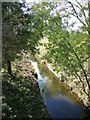
Passing under Den Dungen Bridge
Drainage off Clapton Moor runs under the road bridge; the town of Portishead was twinned with Den Dungen - a village in the Dutch province of North Brabant.
Image: © Neil Owen
Taken: 26 Oct 2022
0.05 miles
3
How Green The Interflow
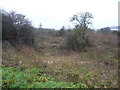
Beneath this seep on the Port Marine site resides a shear at approximately 30 degree north and west when the storm drain, left of photograph, was firstly installed, then provided with a weir. Clay and silt under rubble and dust waste, now tree planted. How much of the interflow caused the ground for the slip and how much the slip and storm drain affect the interflow may provide the elderly foreman and the excavator driver who restored the slope with some hours of contemplation, in winter rain this being less of a hazard than in the deep mud and the slog through the works, alongside this steep main flood channel edge toward the Severn estuary.
Image: © MDS
Taken: 10 Feb 2007
0.06 miles
4
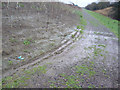
Interflow Soils Part Deux
This is a 2003 October photograph of the works Rhyne and storm drain.
A small shear is behind the pipe, the large shear was north west of this.
Image: © MDS
Taken: Unknown
0.06 miles
5
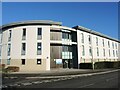
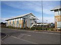
Marina Healthcare Centre
Part of the new expansion of Portishead has brought N.H.S. services to the town.
Image: © Neil Owen
Taken: 2 Jan 2023
0.08 miles
7
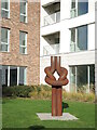
An iron knot
Another piece of maritime art in Portishead.
Image: © Neil Owen
Taken: 26 Oct 2022
0.09 miles
8
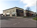
Gordano Gate
Part of the new business park. On the left is Serbert Road.
Image: © Derek Harper
Taken: 1 Apr 2010
0.11 miles
9
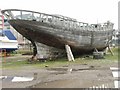
Dockside, Portishead
Glorious lines of a boat under construction or restoration near the dockside. Judging by the condition of the timber it had been there for quite some time. View NW, dock just beyond, with boats for recreation rather than commerce just visible.
Image: © Martin Wilson
Taken: 22 Jul 2004
0.15 miles
10
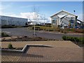
Units at Gordano Gate
The rental firm Hydrex has their HQ in the left-hand building, with its initeresting sloping triangular shelter over the fire escape. A similar feature adorns the UK HQ for DPS (a process system integration firm) on the right, which can be seen in Image In the foreground is Servert Road.
Image: © Derek Harper
Taken: 1 Apr 2010
0.15 miles