IMAGES TAKEN NEAR TO
Winford Close, BRISTOL, BS20 6YG
Introduction
This page details the photographs taken nearby to Winford Close, BS20 6YG by members of the Geograph project.
The Geograph project started in 2005 with the aim of publishing, organising and preserving representative images for every square kilometre of Great Britain, Ireland and the Isle of Man.

There are currently over 7.5m images from over14,400 individuals and you can help contribute to the project by visiting https://www.geograph.org.uk
Image Map (30 Images)


Getting Data...Please wait
Leaflet Map data © OpenStreetMap
Images are licensed for reuse under creativecommons.org/licenses/by-sa/2.0
Notes
- Clicking on the map will re-center to the selected point.
- The higher the marker number, the further away the image location is from the centre of the postcode.
Image Listing (30 Images Found)
Images are licensed for reuse under creativecommons.org/licenses/by-sa/2.0
Image
Details
Distance
1
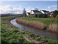
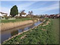
Portbury Ditch
An unappealing name for the sizable watercourse that drain the Gordano valley and runs through the eastern side of the town. Here, with its banks and a grassy area behind, it forms a natural corridor between housing on Brampton Way (right) and Heron Gardens.
Image: © Derek Harper
Taken: 1 Apr 2010
0.09 miles

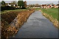
3
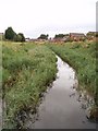
Portbury ditch from Middle bridge
To the north of the sluice gate (and Middle bridge) the water level in Portbury ditch is much lower than to the south. The ditch eventually runs into Portishead marina and the Severn estuary.
Image: © Sharon Loxton
Taken: 31 Jul 2006
0.11 miles
4
Where?s my dinner
A local ginger cat committing woodwork after Frost, before Melt, north along the rhyne ditch.
09:47 04 February 2007 Sunday and the Frost until 09:51
08:45 Monday the much heavier overnight basin microclimate frost, although there was little by midnight, had melted before this submission. It is that hour that makes the difference to survival when migrating to work in the local area.
Image: © MDS
Taken: 4 Feb 2007
0.11 miles
5
Snow in February
"All Day" Snow at Breakfast until ...
Image: © Michael Dennis Stagg
Taken: 18 Feb 2010
0.11 miles
6
Portbury Ditch
Looking the other way, downstream, along Image, with Heron Gardens on the right.
Image: © Derek Harper
Taken: 1 Apr 2010
0.12 miles
7

Wildlife and Weather
Hunting Cat in Territory
Image: © Michael Dennis Stagg
Taken: 22 Dec 2009
0.12 miles
8
Ice to Thaw
The December Snow 20th 21st thaw 22nd 2009
Image: © Michael Dennis Stagg
Taken: 22 Dec 2009
0.12 miles
9
Flood in 2009: neat ! Portbury rhyne ditch expanded
The extent of our flooding as controlled by Somerset Rivers and Highways Agency new works, ponds M5, in great contrast to Workington, to 23 November 2009 midnight and accumulated issues of steep montane basin flows, industrial plain reception
Image: © Michael Dennis Stagg
Taken: 23 Nov 2009
0.14 miles
10

Wot No Gabion
Portishead on the Portbury Rhyne Ditch.
Wall decorations, flood silt, facility collapsing, a piece of Bond Street Bristol gantry that bounces, when a curved arc concrete to mirror the rhyne would have been easier. The vandals set the bridge on fire with the local advertisements paper, the Wessex Water December 2004 closure put the water pipe below the river. The main route for School parents and other less friendly night time travellers.
A swan takes the mode of Darrell Weyman 1969 cartoon What and Get My Feet Wet, only that was a Heron.
Image: © MDS
Taken: 25 Nov 2006
0.15 miles