IMAGES TAKEN NEAR TO
Brampton Way, BRISTOL, BS20 6UY
Introduction
This page details the photographs taken nearby to Brampton Way, BS20 6UY by members of the Geograph project.
The Geograph project started in 2005 with the aim of publishing, organising and preserving representative images for every square kilometre of Great Britain, Ireland and the Isle of Man.

There are currently over 7.5m images from over14,400 individuals and you can help contribute to the project by visiting https://www.geograph.org.uk
Image Map (Loading...)


Getting Data...Please wait
Leaflet Map data © OpenStreetMap
Images are licensed for reuse under creativecommons.org/licenses/by-sa/2.0
Notes
- Clicking on the map will re-center to the selected point.
- The higher the marker number, the further away the image location is from the centre of the postcode.
Image Listing (34 Images Found)
Images are licensed for reuse under creativecommons.org/licenses/by-sa/2.0
Image
Details
Distance
1
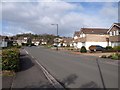
Brampton Way, Portishead
This is the principal road through a large housing estate on the south side of the town. In the background is Fore Hill.
Image: © Derek Harper
Taken: 1 Apr 2010
0.04 miles
2
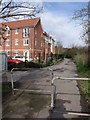
Footpath in Portishead
The public footpath links Forester Road with the High Street. The block of flats on the left is St Peter's Lodge.
Image: © Derek Harper
Taken: 1 Apr 2010
0.08 miles
3
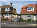
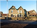
Refurbished
Two houses originally constructed about 1950 and now one has been totally rejuvenated.
Image: © Anthony Clive Woolf
Taken: 26 Jul 2006
0.08 miles
5
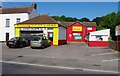
Portishead Tyre & MOT Centre, 160 High Street, Portishead, Somerset
Apparently this is the town's only independent "fast-fit centre". It is a MOT test centre, and includes Viper Valets. The centre was previously a Knights Tyre & Exhaust Centre.
Image: © P L Chadwick
Taken: 9 Jun 2013
0.14 miles
6
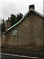
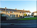
Portishead, The Green Cottage
The cottage carries an Ordnance Survey cut bench mark made for the First Primary Levelling of England and Wales (1840-1860). It is mark No.44 on a branch levelling from Bristol to Portishead and part of a levelling from Bristol to Plymouth. See https://www.geograph.org.uk/photo/6662679 for a close-up and https://www.bench-marks.org.uk/bm42640 for details of the mark.
Image: © Brian Westlake
Taken: 30 Oct 2020
0.14 miles
7
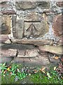
Cut Mark: Portishead, The Green Cottage
Ordnance Survey cut bench mark made for the First Primary Levelling of England and Wales (1840-1860). It is mark No.44 on a branch levelling from Bristol to Portishead and part of a levelling from Bristol to Plymouth. See https://www.geograph.org.uk/photo/6662678 for a wider view and https://www.bench-marks.org.uk/bm42640 for details of the mark.
Image: © Brian Westlake
Taken: 30 Oct 2020
0.14 miles
8
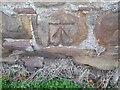
Ordnance Survey Cut Mark
This OS cut mark can be found on The Green Cottage, Bristol Road. It marks a point 7.436m above mean sea level.
Image: © Adrian Dust
Taken: 14 Mar 2022
0.14 miles
10
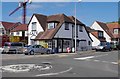
The Corner Cafe, 166 High Street, Portishead, Somerset
The café is located on the corner of the High Street and St. Peter's Road. The crane towering overhead is indicative of the large amount of residential building going on nearby.
Image: © P L Chadwick
Taken: 9 Jun 2013
0.15 miles