IMAGES TAKEN NEAR TO
Avon Road, BRISTOL, BS20 0BB
Introduction
This page details the photographs taken nearby to Avon Road, BS20 0BB by members of the Geograph project.
The Geograph project started in 2005 with the aim of publishing, organising and preserving representative images for every square kilometre of Great Britain, Ireland and the Isle of Man.

There are currently over 7.5m images from over14,400 individuals and you can help contribute to the project by visiting https://www.geograph.org.uk
Image Map
Images are licensed for reuse under creativecommons.org/licenses/by-sa/2.0
Notes
- Clicking on the map will re-center to the selected point.
- The higher the marker number, the further away the image location is from the centre of the postcode.
Image Listing (70 Images Found)
Images are licensed for reuse under creativecommons.org/licenses/by-sa/2.0
Image
Details
Distance
1
Field on the foreshore
Pill Foreshore is listed as: a Ramsar Site, Special Protection Area, Special Area of Conservation and Site of Special Scientific Interest - all at once! The defined land extends up past the M5 bridge on the south side of the Avon.
Image: © Neil Owen
Taken: 22 Mar 2023
0.03 miles
2
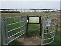
Entry to the Pill Foreshore
A well-listed area, the Pill Foreshore permits careful visitors across the special environment.
Image: © Neil Owen
Taken: 22 Mar 2023
0.05 miles
3
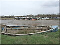
Laid up for a while
A small wooden boat appears to have made its last voyage.
Image: © Neil Owen
Taken: 22 Mar 2023
0.07 miles
5

Community policing
Marine Parade, Pill
Image: © Anthony O'Neil
Taken: 21 Jan 2022
0.08 miles
6
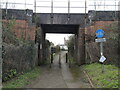
A tunnel between two parts of Pill
The old Bristol and Portishead railway came along in the nineteenth century, when this area was fields. A footpath was respected by the construction of this bridge, which now connects two modern housing developments. A sign restricts passage, but specifically allows low-powered motorbikes and invalid carriages.
Image: © Neil Owen
Taken: 22 Mar 2023
0.09 miles
7
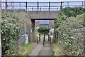
Avon Road Underbridge
At Pill. For decades there has been talk of the railway to Bristol re-opening to passenger services but still no sign of it happening.
Image: © Anthony O'Neil
Taken: 21 Jan 2022
0.09 miles
8
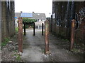
Under Avon Road Underbridge
To prevent motorised traffic, several posts have been embedded under the railway bridge. They seem to be sections of rail track.
Image: © Neil Owen
Taken: 22 Mar 2023
0.09 miles
9
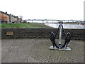
An anchor on Marine Parade
A suitably nautical talking piece on the riverside. The flood defences were built by the National Rivers Authority (of old) in 1992.
Image: © Neil Owen
Taken: 22 Mar 2023
0.10 miles
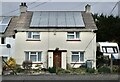
10
Houses in Lodway
These semi detached houses are at the junction of Hardwick Rd and Lodway Close.
Image: © Nigel Mykura
Taken: 20 Jan 2017
0.10 miles