IMAGES TAKEN NEAR TO
BS19 5BA
Introduction
This page details the photographs taken nearby to BS19 5BA by members of the Geograph project.
The Geograph project started in 2005 with the aim of publishing, organising and preserving representative images for every square kilometre of Great Britain, Ireland and the Isle of Man.

There are currently over 7.5m images from over14,400 individuals and you can help contribute to the project by visiting https://www.geograph.org.uk
Image Map
Images are licensed for reuse under creativecommons.org/licenses/by-sa/2.0
Notes
- Clicking on the map will re-center to the selected point.
- The higher the marker number, the further away the image location is from the centre of the postcode.
Image Listing (207 Images Found)
Images are licensed for reuse under creativecommons.org/licenses/by-sa/2.0
Image
Details
Distance
1
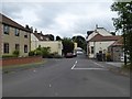
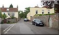
Part of Smallway, Congresbury
Smallway is a road which has a short stretch (here) between Bristol Road and Kent Road and a longer stretch north from Bristol Road to Frost Hill
Image: © David Smith
Taken: 26 Jul 2016
0.03 miles
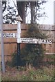
2
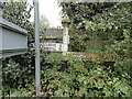
Partly-hidden old signpost, Congresbury
At the right edge of the view, no longer visible to motorists (and nearly missed by this pedestrian) is a short signpost with a pyramid-shaped cap carrying the initials SCC (Somerset County Council).
One arm points left (north) along the A370 towards Cleeve (2) and Bristol (12). The other arm points south towards Langford (3) and Bridgwater (23). Distances are in miles.
Image: © Jaggery
Taken: 23 Jul 2011
0.03 miles
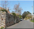
3
Smallway, Congresbury
Seen across the A370 junction. At the end of the road is the junction with Kents Road shown in Image On the left beyond the lights is Sheppy's Mill, a modern development.
Image: © Derek Harper
Taken: 3 Jun 2006
0.03 miles
4
Direction Sign - Signpost on the A370 Bristol Road in Congresbury
Pyramid finial - 2 arms; Somerset SCC pyramid by the A370, in parish of Congresbury (North Somerset District), on the southeast side of the crossroads of the A370 Bristol Road and the B3133 Smallway. For a more recent photo, see https://www.geograph.org.uk/photo/7650979.
Surveyed
Milestone Society National ID: SO_ST4364
Image: © J Dowding
Taken: 1 Aug 2013
0.03 miles
5
Direction Sign - Signpost on the A370 Bristol Road in Congresbury
Located on the southeast side of the crossroads of the A370 Bristol Road and the B3133 Smallway in Congresbury parish. 4 arms, 2 missing, and pyramid finial. For an older photo, see https://www.geograph.org.uk/photo/6098484.
Milestone Society National ID: SO_ST4364
Image: © Roadside Relics
Taken: 16 Oct 2023
0.03 miles
6
Kent Road, Congresbury
The B3169 at the junction with Smallway, connecting to the A370. Kent Road must have once been the main road through Congresbury - see http://www.sabre-roads.org.uk/wiki/index.php?title=B3169 for a discussion of relevant road numbering. The house on the right is "The Old Malthouse" - I like the Gothic door in the wall. As Cypress Lodge, this was a Quaker meeting house in the mid-C19 http://www.claverhammeetinghouse.org.uk/news/2010/4/28/metfords-of-claverham-meeting.html .
Image: © Derek Harper
Taken: 16 May 2011
0.03 miles
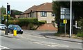
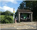
8
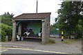
Decorated bus shelter near Congresbury Bridge
Image: © David Smith
Taken: 26 Jul 2016
0.06 miles
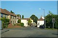
10
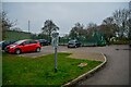
Congresbury : Car Park
A car park off Gooseham Mead.
Image: © Lewis Clarke
Taken: 24 Jan 2022
0.07 miles