IMAGES TAKEN NEAR TO
Commercial Road, BRISTOL, BS1 6TQ
Introduction
This page details the photographs taken nearby to Commercial Road, BS1 6TQ by members of the Geograph project.
The Geograph project started in 2005 with the aim of publishing, organising and preserving representative images for every square kilometre of Great Britain, Ireland and the Isle of Man.

There are currently over 7.5m images from over14,400 individuals and you can help contribute to the project by visiting https://www.geograph.org.uk
Image Map
Images are licensed for reuse under creativecommons.org/licenses/by-sa/2.0
Notes
- Clicking on the map will re-center to the selected point.
- The higher the marker number, the further away the image location is from the centre of the postcode.
Image Listing (1191 Images Found)
Images are licensed for reuse under creativecommons.org/licenses/by-sa/2.0
Image
Details
Distance
1
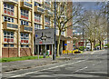
Approaching Bedminster roundabout
Cumberland Road, Bristol
Image: © Anthony O'Neil
Taken: 19 Mar 2023
0.01 miles
2
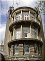
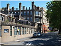
Round lookout
Part of the old Bristol General Hospital complex as was, this elegant addition was one of many to the original buildings. Opened in 1832 it slowly accrued new extensions and redevelopments; bomb damage from WWII also gave it a chance to change once again. However, the opening of new hospitals in the 2010s meant that this venerable old place was closed in April 2012.
Image: © Neil Owen
Taken: 22 May 2013
0.01 miles
3
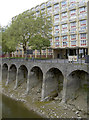
The New Cut at low tide
The New Cut was hand-dug out of the south Bristol area in the early 1800s to allow the River Avon to carry on its tidal rise and fall whilst the old rivercourse was turned into the Floating Harbour. Here are some of the supporting buttresses in front of the large block of flats of Waring and Francombe House.
Image: © Neil Owen
Taken: 22 May 2013
0.02 miles
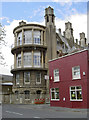
4
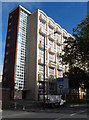
Francombe House, Bristol
Multi-storey block of flats in Commercial Road.
Image: © Jaggery
Taken: 21 Oct 2012
0.02 miles
5
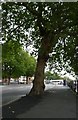
Bristol : Commercial Road, Pavement & Tree
Image: © Lewis Clarke
Taken: 7 Oct 2009
0.02 miles
6
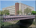
Waring House, Redcliff Hill, Bristol
A singular block, distinguished by the procession of shallow arches, which, Pevsner observes, neatly echo the revetments to the river below (Image]). Built 1958-60 to the designs of the City Architect's Department.
In front is the attractive ironwork of Bedminster Bridge, built 1883 (Image]). It is almost imperceptibly arched. Grade II listed.
Image: © Stephen Richards
Taken: 21 May 2012
0.02 miles
7
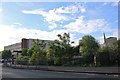
York Road, Bedminster
Looking towards offices on Redcliffe Hill
Image: © David Howard
Taken: 1 Jun 2019
0.03 miles
8
Former General Hospital - BS1
A view of one aspect of the former Bristol General Hospital on Commercial Road. This picture is taken from the Lower Guinea Street junction, looking in the direction of Bedminster Bridge.The hospital opened in 1832 for the exclusive care of Bristol patients only, expanding to outsiders in 1850. It was a non-acute rehabilitation hospital with some impressive views across Bathurst Basin from one side of the building. The BNP Paribas' estate agency was instructed to sell the site in late 2010 after a development brief was compiled for the 3 acre site by planners and agreed to by Bristol City Council. The wards closed on 3rd April 2012 and the remaining patients were transferred to South Bristol Community Hospital. Locals say that most of it is to be converted into apartments.
Image: © David Hallam-Jones
Taken: 28 Jul 2012
0.03 miles
10
Velindra House
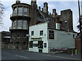
This unassuming little boozer is somewhat dwarfed by the extensions to the old Bristol General Hospital behind it. However, it is still serving (unlike so many others).
The Velindra is said to have been named after a vessel that used to ply its trade along the New Cut in days gone by.
Image: © Neil Owen
Taken: 22 May 2013
0.03 miles