IMAGES TAKEN NEAR TO
Goldfinch Way, BRISTOL, BS16 9SS
Introduction
This page details the photographs taken nearby to Goldfinch Way, BS16 9SS by members of the Geograph project.
The Geograph project started in 2005 with the aim of publishing, organising and preserving representative images for every square kilometre of Great Britain, Ireland and the Isle of Man.

There are currently over 7.5m images from over14,400 individuals and you can help contribute to the project by visiting https://www.geograph.org.uk
Image Map
Images are licensed for reuse under creativecommons.org/licenses/by-sa/2.0
Notes
- Clicking on the map will re-center to the selected point.
- The higher the marker number, the further away the image location is from the centre of the postcode.
Image Listing (16 Images Found)
Images are licensed for reuse under creativecommons.org/licenses/by-sa/2.0
Image
Details
Distance
1
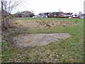
Barrage balloon mooring site
The semi-circle of more scrubby looking grass is the location of a World War Two barrage balloon mooring site in Pucklechurch. There are various small concrete pads set into this area of ground, some with metal rings attached, and also the outline of a small building. The exposed concrete in the foreground is the most obvious feature that would be evident to a casual observer visiting this site.
Image: © Ruth Riddle
Taken: 29 Jan 2011
0.06 miles
2
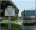
2009 : Pucklechurch twinned with Pringy
I usually remove vehicle registration numbers to avoid possible embarrassment but was unable to resist the temptation to leave this one in.
Image: © Maurice Pullin
Taken: 19 Sep 2009
0.14 miles
3
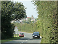
2009 : Pucklechurch, the southern approaches
Coming in on the minor road from Abson and Wick.
This could be worth and entry in the Uxbridge dictionary of place names.
Image: © Maurice Pullin
Taken: 19 Sep 2009
0.16 miles
4
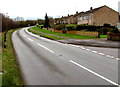
Abson Road, Pucklechurch
Looking SSE past the Oaktree Avenue junction http://www.geograph.org.uk/photo/4816607 on the right.
Image: © Jaggery
Taken: 5 Feb 2016
0.18 miles
5
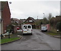
Holly Close, Pucklechurch
On the southeast side of Oaktree Avenue.
Image: © Jaggery
Taken: 5 Feb 2016
0.19 miles
6
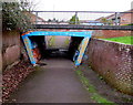
Southeast side of a pedestrian underpass, Pucklechurch
Under Oaktree Avenue.
Image: © Jaggery
Taken: 5 Feb 2016
0.20 miles
7
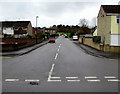
Oaktree Avenue, Pucklechurch
Viewed across Abson Road.
Image: © Jaggery
Taken: 5 Feb 2016
0.20 miles
8
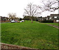
Grass, trees and houses, Pucklechurch
Oaktree Avenue is on the left.
Image: © Jaggery
Taken: 5 Feb 2016
0.20 miles
9
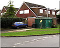
Oaktree Avenue electricity substation, Pucklechurch
The dark green cabinet on the corner of Oaktree Avenue and Holly Close is a Western Power Distribution (South West) electricity substation. Its identifier is 2305 OAKTREE AVE P S/S.
Image: © Jaggery
Taken: 5 Feb 2016
0.20 miles
10
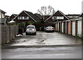
Oaktree Avenue lockup garages, Pucklechurch
Between Oaktree Avenue and Holly Close.
Image: © Jaggery
Taken: 5 Feb 2016
0.21 miles