IMAGES TAKEN NEAR TO
Lansdown Road, BRISTOL, BS16 9RG
Introduction
This page details the photographs taken nearby to Lansdown Road, BS16 9RG by members of the Geograph project.
The Geograph project started in 2005 with the aim of publishing, organising and preserving representative images for every square kilometre of Great Britain, Ireland and the Isle of Man.

There are currently over 7.5m images from over14,400 individuals and you can help contribute to the project by visiting https://www.geograph.org.uk
Image Map
Images are licensed for reuse under creativecommons.org/licenses/by-sa/2.0
Notes
- Clicking on the map will re-center to the selected point.
- The higher the marker number, the further away the image location is from the centre of the postcode.
Image Listing (145 Images Found)
Images are licensed for reuse under creativecommons.org/licenses/by-sa/2.0
Image
Details
Distance
1
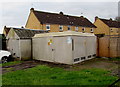
Castle Road electricity substation Pucklechurch
The Western Power Distribution (South West) electricity substation identifier is 1854 CASTLE RD.
Image: © Jaggery
Taken: 5 Feb 2016
0.03 miles
2
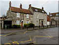
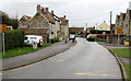
Castle Road houses, Pucklechurch
The yellow road markings are near the village school entrance. http://www.geograph.org.uk/photo/5068150
Image: © Jaggery
Taken: 5 Feb 2016
0.03 miles
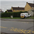
3
Yellow No Stopping sign, Castle Road, Pucklechurch
The sign is alongside zigzag yellow markings outside the village primary
school defining the Keep Clear Zone from 8am to 5pm on Monday-Friday .
Image: © Jaggery
Taken: 5 Feb 2016
0.03 miles
4
BT Sport van, Castle Road, Pucklechurch
Launched on August 1st 2013, BT Sport is a group of sports television channels provided by BT Consumer, a division of BT Group in the UK and Ireland. BT Sport is available to BT TV, Sky and Virgin Media subscribers.
Image: © Jaggery
Taken: 5 Feb 2016
0.03 miles
5
Zigzag markings on Castle Road, Pucklechurch
Marking the keep clear zone outside the village primary school.
The yellow notices state No stopping Mon-Fri 8am-5pm on entrance markings.
Image: © Jaggery
Taken: 5 Feb 2016
0.04 miles
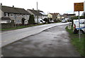
6
Castle Road bus stop, Pucklechurch
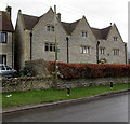
No BUS STOP road marking here, only a bus stop sign on a wooden pole.
The stop is in front of Grade II listed Harwood Farmhouse, dating from the 17th century.
Image: © Jaggery
Taken: 5 Feb 2016
0.04 miles
7
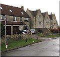
20mph zone on the approach to the village school, Pucklechurch
The small round sign showing 20 faces Castle Road on the approach to Pucklechurch CE VC Primary School.
Grade II listed Harwood Farmhouse, dating from the 17th century, is on the right.
Image: © Jaggery
Taken: 5 Feb 2016
0.04 miles
8
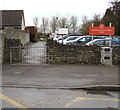
Castle Road entrance to the village school, Pucklechurch
Entrance path to Pucklechurch Church of England Voluntary Controlled Primary School. A Voluntary Controlled school must provide for all pupils to take part in a daily act of collective worship, which must reflect the broad traditions of Christian belief and be wholly Christian in character.
Image: © Jaggery
Taken: 5 Feb 2016
0.05 miles
9
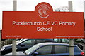
Pucklechurch CE VC Primary School nameboard
Located here. http://www.geograph.org.uk/photo/5068150 CE=Church of England VC= Voluntary Controlled. A Voluntary Controlled school must provide for all pupils to take part in a daily act of collective worship, which must reflect the broad traditions of Christian belief and be wholly Christian in character.
Image: © Jaggery
Taken: 5 Feb 2016
0.05 miles
10
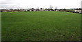
Pucklechurch Recreation Ground
On the north side of Pucklechurch Community Centre and Social Club. http://www.geograph.org.uk/photo/4818059
Image: © Jaggery
Taken: 5 Feb 2016
0.05 miles