IMAGES TAKEN NEAR TO
The Pines, BRISTOL, BS16 9QY
Introduction
This page details the photographs taken nearby to The Pines, BS16 9QY by members of the Geograph project.
The Geograph project started in 2005 with the aim of publishing, organising and preserving representative images for every square kilometre of Great Britain, Ireland and the Isle of Man.

There are currently over 7.5m images from over14,400 individuals and you can help contribute to the project by visiting https://www.geograph.org.uk
Image Map
Images are licensed for reuse under creativecommons.org/licenses/by-sa/2.0
Notes
- Clicking on the map will re-center to the selected point.
- The higher the marker number, the further away the image location is from the centre of the postcode.
Image Listing (41 Images Found)
Images are licensed for reuse under creativecommons.org/licenses/by-sa/2.0
Image
Details
Distance
2
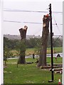
'Inside' Mangotsfield Station
Only the walls remain of the building of Mangotsfield Station. Two cycle paths run either side of the station where the trains once ran.
Image: © Linda Bailey
Taken: 12 Aug 2006
0.12 miles
3
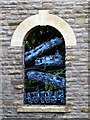
Old Mangotsfield Station - train window
Image: © Linda Bailey
Taken: 12 Aug 2006
0.12 miles
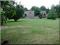
4
Old Mangotsfield Station
The platforms still remain but its now the Bristol to Bath Cycle Path that passes through.
Image: © Linda Bailey
Taken: 12 Aug 2006
0.12 miles
5
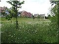
Siston Hill Housing Estate
Flood plain for Siston Brook
Image: © Andy Stone
Taken: 20 Jun 2012
0.13 miles
6
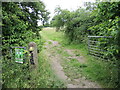
Gateway to Siston Common
A poster warns that dog-owners will have to carry means to clean up after them or risk a £1000 fine.
Image: © Neil Owen
Taken: 24 Jun 2021
0.14 miles
7
Ridley Avenue
Entrance to Siston Hill housing estate
Image: © Andy Stone
Taken: 24 Jun 2012
0.15 miles
8
A cattle grid - but no cattle
Siston Common was once a more unified open space but is now divided by modern roads for the main part. However, some elements of the old ways still carry on today - witness this cattle grid. No sign of any cows at the present, although commoners' rights must still be met.
Image: © Neil Owen
Taken: 26 Sep 2018
0.16 miles
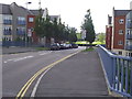
9
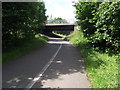
Ridley Avenue Bridge
Ridley Avenue crosses the Bristol & Bath cycle path on the course of the former Mangotsfield to Bath branch line.
Image: © Andy Stone
Taken: 24 Jun 2012
0.16 miles
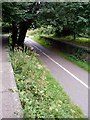
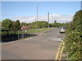
10

Travelling by Mangotsfield Station
The Midland Railway built lines in this part of Bristol from 1845, based on earlier horse-drawn coal trams from 1828. The station became an important junction between two lines to Bath and the Midlands, but never really achieved great success. It finally closed in 1966 under the Beeching axe.
Today the trackbed and platforms are used by less polluting and slower traffic.
Image: © Neil Owen
Taken: 24 Jun 2021
0.17 miles