IMAGES TAKEN NEAR TO
Rodway Hill, BRISTOL, BS16 9LQ
Introduction
This page details the photographs taken nearby to Rodway Hill, BS16 9LQ by members of the Geograph project.
The Geograph project started in 2005 with the aim of publishing, organising and preserving representative images for every square kilometre of Great Britain, Ireland and the Isle of Man.

There are currently over 7.5m images from over14,400 individuals and you can help contribute to the project by visiting https://www.geograph.org.uk
Image Map
Images are licensed for reuse under creativecommons.org/licenses/by-sa/2.0
Notes
- Clicking on the map will re-center to the selected point.
- The higher the marker number, the further away the image location is from the centre of the postcode.
Image Listing (41 Images Found)
Images are licensed for reuse under creativecommons.org/licenses/by-sa/2.0
Image
Details
Distance
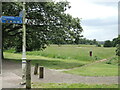
1
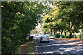
2011 : Rodway Hill, Mangotsfield
Looking north toward Mangotsfield village.
The road is named "Rodway Hill" the open space is to the left of the road.
Image: © Maurice Pullin
Taken: 2 Sep 2011
0.05 miles
2
Mangotsfield School
On Rodway Hill. http://www.mangotsfieldschool.org.uk/
Image: © Mike Faherty
Taken: 29 Oct 2010
0.06 miles
3
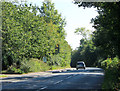
2011 : Rodway Hill, near Mangotsfield
Heading south toward Goose Green and Warmley.
Rodway Hill is the name of the road, Rodway Hill the open space is to the right.
Image: © Maurice Pullin
Taken: 2 Sep 2011
0.07 miles
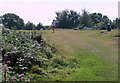
4
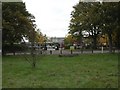
Rodway Hill
An open patch of land which is open to all. In its day it was a place of some quarrying to the west and then became a golf course in the early twentieth century.
Image: © Neil Owen
Taken: 24 Jun 2021
0.08 miles
5
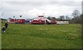
The circus comes to Rodway Hill
Jay Millers circus has toured Britain since 1987.
Image: © Christine Johnstone
Taken: 31 Mar 2018
0.09 miles
6
2011 : Walking the dog on Rodway Hill
Mangotsfield's equivalent of Hyde Park, without the bandstands and the Serpentine, and the Marble Arch, and speakers' corner. Not much like Hyde Park really.
Image: © Maurice Pullin
Taken: 2 Sep 2011
0.09 miles
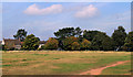
7
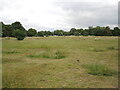
Rodway Hill
Rodway Hill covers an area of around 34.5 acres. The name Rodway comes from the Celtic words 'rod' which means feed and 'way' which means watery. The land originally belonged to the King, and in Saxon times deer, hare, rabbit, wolf, fox and boar were all found here.
Information from a notice board near the road-side.
Image: © Linda Bailey
Taken: 24 May 2006
0.12 miles
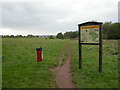
9
Signpost on Rodway Hill
There are many paths to follow over the old common, which is now an open area next to a school.
Image: © Neil Owen
Taken: 24 Jun 2021
0.13 miles
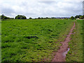
10
2011 : Across Rodway Hill to Manor Road
Some good toboggan slopes along the north west edge of Rodway Hill, real bottom bruisers, best to wait for a good covering of snow though.
Image: © Maurice Pullin
Taken: 2 Sep 2011
0.14 miles