IMAGES TAKEN NEAR TO
Cossham Street, BRISTOL, BS16 9EW
Introduction
This page details the photographs taken nearby to Cossham Street, BS16 9EW by members of the Geograph project.
The Geograph project started in 2005 with the aim of publishing, organising and preserving representative images for every square kilometre of Great Britain, Ireland and the Isle of Man.

There are currently over 7.5m images from over14,400 individuals and you can help contribute to the project by visiting https://www.geograph.org.uk
Image Map (Loading...)


Getting Data...Please wait
Leaflet Map data © OpenStreetMap
Images are licensed for reuse under creativecommons.org/licenses/by-sa/2.0
Notes
- Clicking on the map will re-center to the selected point.
- The higher the marker number, the further away the image location is from the centre of the postcode.
Image Listing (55 Images Found)
Images are licensed for reuse under creativecommons.org/licenses/by-sa/2.0
Image
Details
Distance
1
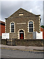
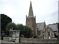
Mangotsfield United Reformed Church
Mangotsfield United Reformed Church is situated on Cossham Street. It was originally a congregational Chapel built in 1827. It was enlarged in 1858. (Dates on the upper plaque).
Image: © Linda Bailey
Taken: 24 May 2006
0.02 miles
2
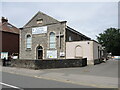
Mangotsfield and Castle Green U.R. church
The church has been here almost as long as the rest of the street; it was founded in 1827 and enlarged in 1853. It was formerly a Congregational tabernacle and sunday school.
Image: © Neil Owen
Taken: 24 Jun 2021
0.02 miles
3
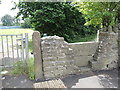
A footpath off Cosham Street
Take either the old stone stile or new gate.
Image: © Neil Owen
Taken: 24 Jun 2021
0.03 miles
4
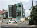
Barry House
An unusual house, built in 2009, occupies a rather acute angle of land along Elmsleigh Road.
Image: © Neil Owen
Taken: 24 Jun 2021
0.04 miles
5

2011 : B4465 Cossham Street, Mangotsfield
Looking east toward Pucklechurch.
Image: © Maurice Pullin
Taken: 2 Sep 2011
0.04 miles
6
St James, Mangotsfield
Back many centuries this area was on the edge of a large hunting forest, not a busy village scene that we have today. St James church was founded and built by William de Putot, Sheriff of Gloucestershire, as a Chapel of Ease between 1222 and 1228 - in the reign of Henry III. It formed part of his estate, which stood close to the present burial ground. That Manor House was demolished in 1846 and the graveyard increased.
Image: © Neil Owen
Taken: 24 Jun 2021
0.06 miles
7
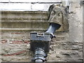
A pipe in place of lead
One of the drain grotesques has had its old sheeting replaced by some awkward looking modern pipe.
Image: © Neil Owen
Taken: 24 Jun 2021
0.06 miles
8
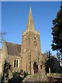
St James in sunlight
A cold but crisp day and the thirteenth century St James stands out.
Image: © Neil Owen
Taken: 24 Jan 2023
0.06 miles
9
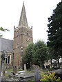
The spire of St James
The church dates back to the thirteenth century. The clock and a peal of bells were presented to the church in 1687. These bells were recast in 1921, and were affectionately known as the “Mangotsfield Buckets”. The present appearance is down to the major renovation of 1851.
Image: © Neil Owen
Taken: 24 Jun 2021
0.06 miles
10
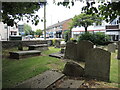
To St James Place
A view from the graveyard and out to St James Place. Until modern times this was a triangular green that held the war memorial. It is now lined with shops and restaurants.
Image: © Neil Owen
Taken: 24 Jun 2021
0.06 miles