IMAGES TAKEN NEAR TO
Cherry Banks, BRISTOL, BS16 7HZ
Introduction
This page details the photographs taken nearby to Cherry Banks, BS16 7HZ by members of the Geograph project.
The Geograph project started in 2005 with the aim of publishing, organising and preserving representative images for every square kilometre of Great Britain, Ireland and the Isle of Man.

There are currently over 7.5m images from over14,400 individuals and you can help contribute to the project by visiting https://www.geograph.org.uk
Image Map (Loading...)


Getting Data...Please wait
Leaflet Map data © OpenStreetMap
Images are licensed for reuse under creativecommons.org/licenses/by-sa/2.0
Notes
- Clicking on the map will re-center to the selected point.
- The higher the marker number, the further away the image location is from the centre of the postcode.
Image Listing (20 Images Found)
Images are licensed for reuse under creativecommons.org/licenses/by-sa/2.0
Image
Details
Distance
1
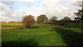
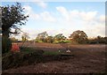
Farmland by Howsmoor Lane
I haven't been able to work out whether all this land by a tributary of the Folly Brook will be developed or not. A map dating from 2006 at http://www.southglos.gov.uk/Documents/PTE060184.pdf suggested not, but the neighbouring field - see Image] - is mapped in the same way. Development is under way across on the left, closer to the M4.
Image: © Derek Harper
Taken: 22 Nov 2013
0.08 miles
3
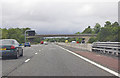
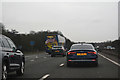
M4 near Emerson's Green, Bristol
Westbound between junctions 18 and 19
Image: © MrC
Taken: 23 Aug 2010
0.13 miles
4
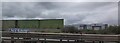
Land by Howsmoor Lane
From the same spot as Image], looking to the left. Beyond the radio transmitter mast (one of two that need to be moved to make way for housing) is a Sainsbury's distribution centre.
Image: © Derek Harper
Taken: 22 Nov 2013
0.14 miles
5

2011 : M4 looking east from the Westerleigh Road overbridge
Toward the Tormarton interchange, five miles.
The echelons were painted on the road to persuade drivers to keep a safe distance apart. A good idea that did not work very well.
Image: © Maurice Pullin
Taken: 20 Jun 2011
0.14 miles
6
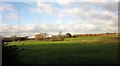
Development site by Howsmoor Lane
Preparations for residential development (part of Emersons Green East), seen from where a principal road will cross Howsmoor Lane. The trees are along a tributary of Folly Brook.
Image: © Derek Harper
Taken: 22 Nov 2013
0.15 miles
7
South Gloucestershire : M4 Motorway
The M4 Motorway between Junction 19 (Hambrook Interchange) and Junction 18 (Tormarton Interchange).
Image: © Lewis Clarke
Taken: 23 Mar 2018
0.15 miles
8
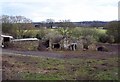
Weston Farm
The derelict remains of Weston Farm near where the Westerleigh Rd crosses the M4
Image: © Steve Coffin
Taken: 27 Feb 2010
0.15 miles
9
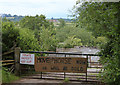
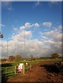
2011 : A not so friendly notice on Westerleigh Road
On a gate actually.
Irresistible, made me chuckle, though doubt if the owner was amused.
Hope he got a good price for it.
Image: © Maurice Pullin
Taken: 20 Jun 2011
0.18 miles
10
Masts, Howsmoor Lane
The Mangotsfield radio transmitter, due to be moved, possibly to near Frampton Cotterell, to make way for housing.
Image: © Derek Harper
Taken: 22 Nov 2013
0.18 miles