IMAGES TAKEN NEAR TO
Westons Brake, BRISTOL, BS16 7BP
Introduction
This page details the photographs taken nearby to Westons Brake, BS16 7BP by members of the Geograph project.
The Geograph project started in 2005 with the aim of publishing, organising and preserving representative images for every square kilometre of Great Britain, Ireland and the Isle of Man.

There are currently over 7.5m images from over14,400 individuals and you can help contribute to the project by visiting https://www.geograph.org.uk
Image Map (Loading...)


Getting Data...Please wait
Leaflet Map data © OpenStreetMap
Images are licensed for reuse under creativecommons.org/licenses/by-sa/2.0
Notes
- Clicking on the map will re-center to the selected point.
- The higher the marker number, the further away the image location is from the centre of the postcode.
Image Listing (7 Images Found)
Images are licensed for reuse under creativecommons.org/licenses/by-sa/2.0
Image
Details
Distance
1
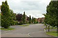
2011 : Westons Brake, Mangotsfield
The style of the houses tells us this is a fairly recent development, a far cry from the 1950's.
The trees, mostly beeches, look to be eight to ten years old.
Image: © Maurice Pullin
Taken: 20 Jun 2011
0.11 miles
2
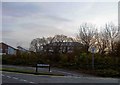
The Brooms on Emerald Green industrial area, Emerson Green near Bristol
The dragon fly sculpture is just visible.
Image: © Steve Fareham
Taken: 9 Dec 2009
0.14 miles
3
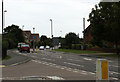
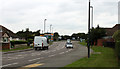
2011 : A432 Badminton Road, Downend, Bristol
Seen from the western end of Westons Brake.
Heading into Downend, Fishponds and Bristol.
Image: © Maurice Pullin
Taken: 20 Jun 2011
0.18 miles
4
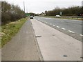
Emerson's Green, lay-by
On Bristol Ring Road, southbound.
Image: © Mike Faherty
Taken: 8 Mar 2015
0.18 miles
5
2011 : A432 Badminton Road, Downend
From the western end of Westons Brake.
Approaching the A4174 Avon Ring Road and roundabout.
The A432 continues to Coalpit Heath and Chipping Sodbury though it does not get as far as Badminton (it did before it became the A432).
Image: © Maurice Pullin
Taken: 20 Jun 2011
0.20 miles
6
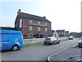
The Willy Wicket Inn
The Willy Wicket was previously Wick Wick Farm, in the ancient parish of Mangotsfield. County assize records show the farm as 'Wekwicha' in 1221. 'Wic' is old English for 'dairy farm' and 'Wike' was derived from an old surnames.
Image: © Eirian Evans
Taken: 7 Apr 2019
0.21 miles
7
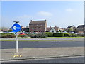
The Willy Wicket Inn
At Wick Wick roundabout
Image: © Eirian Evans
Taken: 7 Apr 2019
0.21 miles