IMAGES TAKEN NEAR TO
St. Stephens Road, BRISTOL, BS16 4RJ
Introduction
This page details the photographs taken nearby to St. Stephens Road, BS16 4RJ by members of the Geograph project.
The Geograph project started in 2005 with the aim of publishing, organising and preserving representative images for every square kilometre of Great Britain, Ireland and the Isle of Man.

There are currently over 7.5m images from over14,400 individuals and you can help contribute to the project by visiting https://www.geograph.org.uk
Image Map
Images are licensed for reuse under creativecommons.org/licenses/by-sa/2.0
Notes
- Clicking on the map will re-center to the selected point.
- The higher the marker number, the further away the image location is from the centre of the postcode.
Image Listing (8 Images Found)
Images are licensed for reuse under creativecommons.org/licenses/by-sa/2.0
Image
Details
Distance
1
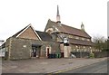
St Stephen's Church, Soundwell
The church, dating from about 1880, occupies the very southwest corner of the square, and the bellcote end of the building is in Image To the left is the church hall.
Image: © Derek Harper
Taken: 26 Mar 2010
0.07 miles
2
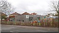
Nursery, Soundwell
Mama Bear’s Soundwell Day Nursery is in purpose-built premises, formerly part of Soundwell College, on Church Road.
Image: © Derek Harper
Taken: 26 Mar 2010
0.10 miles
3
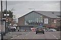
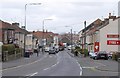
Kingswood : Soundwell Road
Heading along Soundwell Road which heads out of Kingswood. The town's leisure centre can be seen here.
Image: © Lewis Clarke
Taken: 1 Feb 2013
0.13 miles
4
Kingswood Leisure Centre
This is in Upper Soundwell, and is off to the right of the foreground of Image It contains a 33 metre swimming pool ("Bristol Areas largest" proclaims the banner) with three diving boards, a sports hall, two squash courts and a gym.
Image: © Derek Harper
Taken: 26 Mar 2010
0.13 miles
5
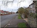
Soundwell Road
The A4017 passing through Upper Soundwell, close to the site of the Downcast coal pit. The area supplied much-needed fuel for the industries of the Bristol area, but retained an independent spirit; Soundwell Road has several C19 non-conformist chapels.
Image: © Derek Harper
Taken: 26 Mar 2010
0.16 miles
6
Gladstone Street, Soundwell
Seen from the point where a footpath runs off to the right towards Church Road alongside the playing field at the rear of Image
Image: © Derek Harper
Taken: 26 Mar 2010
0.18 miles
7
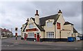
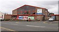
The Shant
A pub on Hopewell Hill, on the corner of Crown Road (left) and Wesley Hill.
Image: © Derek Harper
Taken: 26 Mar 2010
0.20 miles
8
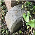
Old Boundary Marker
Municipal Boundary Marker at the end of a brick wall beside the drive to 136 Woodland Way, on the south side of the road. On the boundary of City of Bristol unitary authority and Mangotsfield parish, now with South Gloucestershire unitary authority. Inscribed CB / 18?
Milestone Society National ID: GL_BSMAN02pb
Image: © S Kosciow
Taken: 26 May 2020
0.22 miles