IMAGES TAKEN NEAR TO
Quadrant East, BRISTOL, BS16 4HG
Introduction
This page details the photographs taken nearby to Quadrant East, BS16 4HG by members of the Geograph project.
The Geograph project started in 2005 with the aim of publishing, organising and preserving representative images for every square kilometre of Great Britain, Ireland and the Isle of Man.

There are currently over 7.5m images from over14,400 individuals and you can help contribute to the project by visiting https://www.geograph.org.uk
Image Map
Images are licensed for reuse under creativecommons.org/licenses/by-sa/2.0
Notes
- Clicking on the map will re-center to the selected point.
- The higher the marker number, the further away the image location is from the centre of the postcode.
Image Listing (9 Images Found)
Images are licensed for reuse under creativecommons.org/licenses/by-sa/2.0
Image
Details
Distance
1
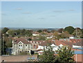
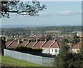
2009 : North from the top of Lodge Hill
The stone built house left foreground was almost certainly made of local stone from quarries in Fishponds.
The houses beyond are part of the Hillfields Park estate built during the 1920/30's by the local council.
In the distance we look over South Gloucestershire in the area of Winterbourne and Coalpit Heath.
Image: © Maurice Pullin
Taken: 12 Oct 2009
0.14 miles
2
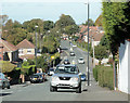
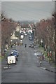
2009 : Henshaw Road leading to Hillfields Avenue
Well remember riding down this hill on the bar of my father's bicycle at the age of 8.
Hillfields Avenue continues from the crossroads at the bottom of the hill.
Image: © Maurice Pullin
Taken: 12 Oct 2009
0.15 miles
4
2009 : North west from the top of Lodge Hill
Cossham Hospital is behind the camera position.
The fence in the foreground protects an electricity sub-station.
Part of the Hillfields Park housing estate, built in the 1920's/30's, is seen followed by factory chimneys in Fishponds. The fine building to the left is the Dower House in the former Duchess Park, now part of Frenchay Hospital I believe.
You Bristolians, especially those living locally will be able to pick out more landmarks including the towers of the Severn Road Bridge taking the M48 from Aust to Beachley Image (the M4 crosses about 2 miles further down).
Image: © Maurice Pullin
Taken: 12 Oct 2009
0.19 miles
5
Bristol : Thicket Avenue
Thicket Avenue heading through residential areas towards Stapleton Road.
Image: © Lewis Clarke
Taken: 1 Feb 2013
0.19 miles
6
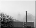
2009 : North of west from the top of Lodge Hill
Near Chester Park, Bristol.
This image fits loosely between Image to the left and Image to the right.
The substantial fence in the foreground surrounds an electricity sub-station. The houses beyond are on Woodland Way.
Further over stands the clock tower in the grounds of Blackberry Hill Hospital, formerly Bristol Mental Hospital, where some of the external scenes in "Casualty", a TV hospital series on BBC 1, were filmed.
Now look a little higher on the screen and you will see, I hope, very faintly, what the authorities call the Second Severn Crossing taking the M4 from Redwick to Caldicot. (In fact it is the fifth Severn crossing, sixth at least if you go back to prehistoric times).
Image: © Maurice Pullin
Taken: 12 Oct 2009
0.20 miles
7
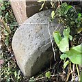
Old Boundary Marker
Municipal Boundary Marker at the end of a brick wall beside the drive to 136 Woodland Way, on the south side of the road. On the boundary of City of Bristol unitary authority and Mangotsfield parish, now with South Gloucestershire unitary authority. Inscribed CB / 18?
Milestone Society National ID: GL_BSMAN02pb
Image: © S Kosciow
Taken: 26 May 2020
0.21 miles
8
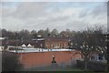
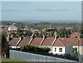
Bristol : View from Lodge Hill
From Lodge Hill looking out across buildings of Bristol.
Image: © Lewis Clarke
Taken: 1 Feb 2013
0.23 miles
9
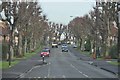
Bristol : Thicket Avenue
Thicket Avenue between Lodge Causeway and Staplehill Road.
Image: © Lewis Clarke
Taken: 1 Feb 2013
0.25 miles