IMAGES TAKEN NEAR TO
Cleevewood Park, Cleeve Wood Road, BRISTOL, BS16 2SX
Introduction
This page details the photographs taken nearby to Cleevewood Park, Cleeve Wood Road, BS16 2SX by members of the Geograph project.
The Geograph project started in 2005 with the aim of publishing, organising and preserving representative images for every square kilometre of Great Britain, Ireland and the Isle of Man.

There are currently over 7.5m images from over14,400 individuals and you can help contribute to the project by visiting https://www.geograph.org.uk
Image Map
Images are licensed for reuse under creativecommons.org/licenses/by-sa/2.0
Notes
- Clicking on the map will re-center to the selected point.
- The higher the marker number, the further away the image location is from the centre of the postcode.
Image Listing (41 Images Found)
Images are licensed for reuse under creativecommons.org/licenses/by-sa/2.0
Image
Details
Distance
1
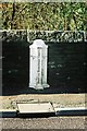
Turnpike boundary marker on Frenchay Bridge
Image: © Adrian Allsop
Taken: 30 May 2010
0.04 miles
2
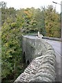
Downend, river bridge
Looking across River Frome towards Frenchay.
Image: © Mike Faherty
Taken: 29 Oct 2010
0.06 miles
3
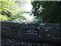
Frenchay: the six ton limit
This notice, dating from the glory days of Chipping Sodbury Rural District Council, is affixed to the old stone bridge across the River at Frenchay village. The bridge itself dates from 1788.
Image: © C P Smith
Taken: 27 Aug 2010
0.07 miles
4
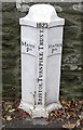
Old Boundary Marker by Cleeve Road, Frenchay, Kingswood parish
Parish Boundary Marker - Turnpike by the UC road, in parish of Kingswood (South Gloucestershire District), Cleeve Road, Frenchay, on bridge over River Frome, against parapet, South side of road.
Inscription reads:-
: MANOR / PH : : 1823 / BRISTOL TURNPIKE TRUST : : WINTER / PH :
Grade II listed.
List Entry Number: 1321087 https://historicengland.org.uk/listing/the-list/list-entry/1321087
Surveyed
Milestone Society National ID: GL_BAFY12pb
Image: © Mike Faherty
Taken: 29 Oct 2010
0.07 miles
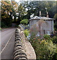
5
Tollhouse by Cleeve Wood Road, Mangotsfield
Tollhouse in the parish of Kingswood (South Gloucestershire District), Turnpike Cottage (Cleeve Wood Lodge), Cleeve Wood Road, BS16.
Grade II listed.
List Entry Number: 1320078 https://historicengland.org.uk/listing/the-list/list-entry/1320078
Surveyed
Milestone Society National ID: AV.KIN01
Image: © Milestone Society
Taken: Unknown
0.07 miles
6
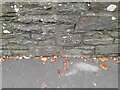
Ordnance Survey Cut Mark
This OS cut mark can be found on the north parapet of Cleeve Wood Road Bridge. It marks a point 33.220m above mean sea level.
Image: © Adrian Dust
Taken: 30 Nov 2022
0.07 miles
7
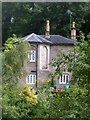
Cleeve Lodge near Frenchay
Located in the valley of the River Frome, the base of the house is below the level of Cleeve Wood Road.
Image: © Jaggery
Taken: 18 Oct 2012
0.07 miles
8
Old turnpike parish boundary marker in Frenchay
Located on the bridge carrying Cleeve Road over the River Frome. Dated 1823, the Bristol Turnpike Trust marker shows Manor P(arish) on the left and Winter P(arish) on the right.
Image: © Jaggery
Taken: 18 Oct 2012
0.07 miles
9
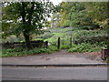
Frenchay, kissing gate
Leading to the National Trust's Frenchay Moor.
Image: © Mike Faherty
Taken: 29 Oct 2010
0.08 miles
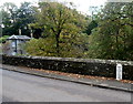
10
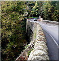
South side of the Cleeve Road bridge over the River Frome, Frenchay
The river is several metres below the road.
Image: © Jaggery
Taken: 18 Oct 2012
0.09 miles