Old Boundary Marker by Cleeve Road, Frenchay, Kingswood parish
Introduction
The photograph on this page of Old Boundary Marker by Cleeve Road, Frenchay, Kingswood parish by Mike Faherty as part of the Geograph project.
The Geograph project started in 2005 with the aim of publishing, organising and preserving representative images for every square kilometre of Great Britain, Ireland and the Isle of Man.

There are currently over 7.5m images from over 14,400 individuals and you can help contribute to the project by visiting https://www.geograph.org.uk
Old Boundary Marker by Cleeve Road, Frenchay, Kingswood parish
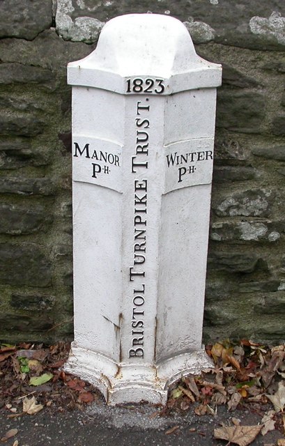
Image: © Mike Faherty Taken: 29 Oct 2010
Parish Boundary Marker - Turnpike by the UC road, in parish of Kingswood (South Gloucestershire District), Cleeve Road, Frenchay, on bridge over River Frome, against parapet, South side of road. Inscription reads:- : MANOR / PH : : 1823 / BRISTOL TURNPIKE TRUST : : WINTER / PH : Grade II listed. List Entry Number: 1321087 https://historicengland.org.uk/listing/the-list/list-entry/1321087 Surveyed Milestone Society National ID: GL_BAFY12pb
Images are licensed for reuse under creativecommons.org/licenses/by-sa/2.0
Image Location
Latitude
51.497131
Longitude
-2.513875