IMAGES TAKEN NEAR TO
Wright Way, BRISTOL, BS16 1WE
Introduction
This page details the photographs taken nearby to Wright Way, BS16 1WE by members of the Geograph project.
The Geograph project started in 2005 with the aim of publishing, organising and preserving representative images for every square kilometre of Great Britain, Ireland and the Isle of Man.

There are currently over 7.5m images from over14,400 individuals and you can help contribute to the project by visiting https://www.geograph.org.uk
Image Map
Images are licensed for reuse under creativecommons.org/licenses/by-sa/2.0
Notes
- Clicking on the map will re-center to the selected point.
- The higher the marker number, the further away the image location is from the centre of the postcode.
Image Listing (36 Images Found)
Images are licensed for reuse under creativecommons.org/licenses/by-sa/2.0
Image
Details
Distance
1
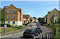
2011 : Excellent houses, pity about the roads
Am fully in favour of traffic calming but this is taking things a bit too far. Drove round here in frustration looking for somewhere to stop for a geograph or two, all double yellow lines, then found a single yellow line and heaved a sigh of relief.
This is at the end of Jellicoe Avenue, hope they will find the Wright Way soon.
Off Coldharbour Lane, between the University of the West of England and the Dower House.
Image: © Maurice Pullin
Taken: 2 May 2011
0.03 miles
2
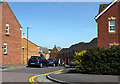
2011 : Trellick Way, near Harry Stoke
A modern development near the University of West of England.
Image: © Maurice Pullin
Taken: 2 May 2011
0.09 miles
3
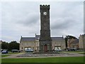
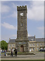
Clock Tower in Stoke Park
This clock tower is on the Stoke Park Estate, just to the northeast of the Dower House. Each of the four faces has stopped at a different time.
Image: © Brett Norris
Taken: 17 Aug 2009
0.09 miles
4
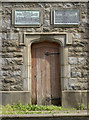
Burden Tower doorway
Two plaques above the entrance reveal the tower is dedicated to the priest, Harold Burden. He was a local man who was associated with the nearby Dower House and pioneered mental health care around a century ago. The second plaque is dedicated to Burden's second wife, Rosa, who also devoted much of her efforts to the cause. See http://www.geograph.org.uk/photo/4949806 for a wider view.
Image: © Neil Owen
Taken: 13 May 2016
0.10 miles
5
The Burden Tower
This impressive tower was built by the Berkeley family, owners of nearby Stoke Park (Dower House) in honour of the Reverend Harold Nelson Burden. The popular priest gave much emphasis on care for those who were suffering from various mental health issues, especially children. Growing from this work, the area became a leading force in this area of health care for many years. See http://www.geograph.org.uk/photo/4949815 for a look at the plaques.
Image: © Neil Owen
Taken: 13 May 2016
0.10 miles
6

Clock Tower from Thomas Way
There is an OS benchmark Image on the left face of the near corner
Image: © Roger Templeman
Taken: 9 Apr 2013
0.10 miles
7
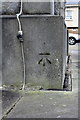
Benchmark on the clock tower on the former Stoke Park Hospital site
Ordnance Survey cut mark benchmark described on the Bench Mark Database at http://www.bench-marks.org.uk/bm47952
Image: © Roger Templeman
Taken: 9 Apr 2013
0.10 miles
8
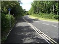
Road adjacent to UWE and the Stoke Park Estate
This was the road that previously used to be the back entrance to the Hewlett Packard estate. Now closed to traffic awaiting redevelopment of the site for the UWE (University of the West of England) extension.
Image: © Brett Norris
Taken: 11 Aug 2009
0.12 miles
9
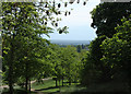
2011 : View south from Jellicoe Avenue
Open parkland with trees looking south over east Bristol though it is well hidden. Dundry Hill is in the distance.
Image: © Maurice Pullin
Taken: 2 May 2011
0.13 miles
10
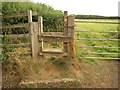
Stile by Coldharbour Lane
The start of footpath LSG/25, which crosses to the wood on the far side of the cattle pasture.
Image: © Derek Harper
Taken: 7 Sep 2013
0.13 miles