IMAGES TAKEN NEAR TO
Bury Hill, Moorend, BRISTOL, BS16 1SS
Introduction
This page details the photographs taken nearby to Bury Hill, Moorend, BS16 1SS by members of the Geograph project.
The Geograph project started in 2005 with the aim of publishing, organising and preserving representative images for every square kilometre of Great Britain, Ireland and the Isle of Man.

There are currently over 7.5m images from over14,400 individuals and you can help contribute to the project by visiting https://www.geograph.org.uk
Image Map
Images are licensed for reuse under creativecommons.org/licenses/by-sa/2.0
Notes
- Clicking on the map will re-center to the selected point.
- The higher the marker number, the further away the image location is from the centre of the postcode.
Image Listing (14 Images Found)
Images are licensed for reuse under creativecommons.org/licenses/by-sa/2.0
Image
Details
Distance
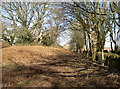
1
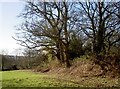
Around the south of Bury Hill
The ramparts of the hillfort turn towards the River Frome. The site is on a plateau above the river and uses some of the steep rock faces as defence. This side is rather more flat.
Image: © Neil Owen
Taken: 7 Feb 2018
0.02 miles
2
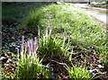
Crocuses on Bury Hill
The morning frost and clear skies have highlighted these seasonal blooms.
Image: © Neil Owen
Taken: 7 Feb 2018
0.04 miles
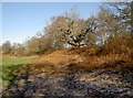
3
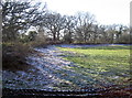
By the eastern entrance of Bury Hill
The Iron Age fort occupies a plateau overlooking the Frome valley. Its history seems to indicate a couple of periods of use, one pre-Roman, the other Roman.
This view south of the eastern entrance shows some ramparts, dusted by earlier snow, and the trees lining the tops.
Image: © Neil Owen
Taken: 7 Feb 2018
0.04 miles
4
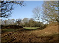
A gap in the earthworks
This is Bury Hill fort's entrance from the east. The site seems to have been used in two or three main eras: excavations have produced materials from the palaeolithic, indicating the earliest occupation; later finds include Iron Age and late Roman.
Image: © Neil Owen
Taken: 7 Feb 2018
0.05 miles
5
The ramparts along Up Yonder!
Bury Hill fort is flanked on the east by a lane to Up Yonder. The fort appears to have two sets of ramparts and ditches, the outer slightly higher than the inner; this has led to speculation that the fort was originally Iron Age and smaller, but later Roman era additions were made.
Image: © Neil Owen
Taken: 7 Feb 2018
0.06 miles
6
North of the eastern entrance
Bury Hill fort is largely bivallate - having two sets of ramparts - enclosing a roughly rectangular area. This is the view north from the open east entrance where the smoothed earthworks are topped by the trees and shrubs.
Image: © Neil Owen
Taken: 7 Feb 2018
0.06 miles
7
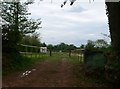
Entrance gate to Green Gables Caravan site
A quiet location, near Hambrook.
Image: © Eirian Evans
Taken: 17 May 2012
0.07 miles
8
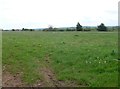
Field at Green Gables
Field to be used by caravaners - this is a new site and we were the first on it!
Image: © Eirian Evans
Taken: 17 May 2012
0.08 miles
9
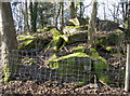
Mosst rocks
Bury Hill contains the earthworks of a hillfort and plenty of more recent quarrying. Large rocks are covered in a natural velvet.
Image: © Neil Owen
Taken: 7 Feb 2018
0.10 miles
10
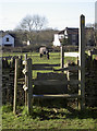
The path goes through my dinner
The footpath near Moorend crosses this rickety stile and runs through this handsome fellow's patch.
Image: © Neil Owen
Taken: 7 Feb 2018
0.11 miles