IMAGES TAKEN NEAR TO
Bristol Road, BRISTOL, BS16 1SB
Introduction
This page details the photographs taken nearby to Bristol Road, BS16 1SB by members of the Geograph project.
The Geograph project started in 2005 with the aim of publishing, organising and preserving representative images for every square kilometre of Great Britain, Ireland and the Isle of Man.

There are currently over 7.5m images from over14,400 individuals and you can help contribute to the project by visiting https://www.geograph.org.uk
Image Map
Images are licensed for reuse under creativecommons.org/licenses/by-sa/2.0
Notes
- Clicking on the map will re-center to the selected point.
- The higher the marker number, the further away the image location is from the centre of the postcode.
Image Listing (31 Images Found)
Images are licensed for reuse under creativecommons.org/licenses/by-sa/2.0
Image
Details
Distance
1
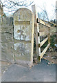
Old Milestone by the B4058, Bristol Road, Winterbourne parish
Carved stone post by the B4058, in parish of WINTERBOURNE (SOUTH GLOUCESTERSHIRE District), Bristol Road, Hambrook, just West of motorway, end of stone wall, next to gate, on South side of road. Erected by the Sodbury Division turnpike trust in the 19th century.
Defaced inscription reads:-
TO
(BATH)
14
TO
(BRISTOL)
5
Carved benchmark lower face.
Milestone Society National ID: GL_BRWE05.
Image: © R Shackell
Taken: Unknown
0.06 miles
2
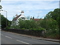
The milestone by the White Horse Inn
Looking eastwards to Whiteshill, with a milestone and the White Horse Inn. See Image] for a look at the former roadside feature.
Image: © Neil Owen
Taken: 30 May 2019
0.06 miles
3
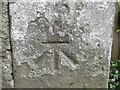
Benchmark on Whiteshill milestone
A cutmark, as listed in the Benchmark Database: https://www.bench-marks.org.uk/bm84752 on a milestone close to the White Horse Inn. See Image] for a wider look.
Image: © Neil Owen
Taken: 30 May 2019
0.06 miles
4
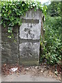
Milestone on the B4058
A large milestone headed to Whiteshill. It should read 'Bath 14, Bristol 5' but the years have not been kind. See Image] for a closer look at the benchmark - an original mark of the nineteenth century.
Image: © Neil Owen
Taken: 30 May 2019
0.06 miles
5
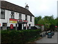
The White Horse, Hambrook
This old pub has been run by the same family for over 30 years.
Image: © Eirian Evans
Taken: 17 May 2012
0.06 miles
6
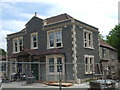
Changing yet again
New owners are currently renovating this old pub. In previous incarnations it was a Chinese restaurant, before that it was known as The Hambrook. Interestingly, it was first a pub called The Black Horse - rather strangely as The White Horse pub is but a very short stagger from it and in clear line of sight. The latter is still trading.
Image: © Neil Owen
Taken: 25 May 2019
0.07 miles
7
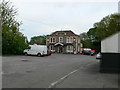
Lucky Dragon Chinese Restaurant
At The Hambrook - this must have been a public house at one time.
Image: © Eirian Evans
Taken: 17 May 2012
0.07 miles
8
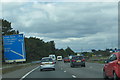
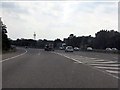
Along the M4
Approaching the M32 slip-road to Bristol city centre.
Image: © Robert Ashby
Taken: 16 Aug 2014
0.08 miles
9
M4 Motorway - joining eastbound at junction 19
Image: © J Whatley
Taken: 22 Sep 2010
0.09 miles
10
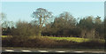
Field and trees by the M4
Taken from the westbound exit slip road at junction 19. The trees overlook a public footpath and are at the top of a wood that drops to the Bradley Brook.
Image: © Derek Harper
Taken: 19 Jan 2018
0.10 miles