IMAGES TAKEN NEAR TO
Long Down Avenue, BRISTOL, BS16 1FP
Introduction
This page details the photographs taken nearby to Long Down Avenue, BS16 1FP by members of the Geograph project.
The Geograph project started in 2005 with the aim of publishing, organising and preserving representative images for every square kilometre of Great Britain, Ireland and the Isle of Man.

There are currently over 7.5m images from over14,400 individuals and you can help contribute to the project by visiting https://www.geograph.org.uk
Image Map (Loading...)


Getting Data...Please wait
Leaflet Map data © OpenStreetMap
Images are licensed for reuse under creativecommons.org/licenses/by-sa/2.0
Notes
- Clicking on the map will re-center to the selected point.
- The higher the marker number, the further away the image location is from the centre of the postcode.
Image Listing (34 Images Found)
Images are licensed for reuse under creativecommons.org/licenses/by-sa/2.0
Image
Details
Distance
1
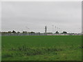
Playing fields
A view looking due south across the playing fields and sports pitches of Lockleaze school. The Bristol telecoms tower at ST610764 can be seen in the background
Image: © Phil Williams
Taken: 10 Nov 2005
0.06 miles
2
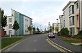
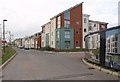
Long Down Avenue, Bristol
Further north along the road shown in Image On the left is Little Locky Close.
Image: © Derek Harper
Taken: 29 Sep 2014
0.07 miles
3
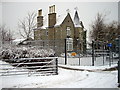
Stanley Farm
Once the Farm Managers house for Wallscourt Farm, saved from dereliction by MOD and used as their training centre
Image: © Steve Coffin
Taken: 5 Feb 2009
0.11 miles
4
Ashley Down Old Boys RFC hut
Part of a Stanley Farm building is visible above the Rugby Football Club building.
Image: © Roger Templeman
Taken: 24 Mar 2012
0.11 miles
5
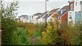
Drainage channel by Long Down Avenue
This housing is a 21st century development to provide homes for the bustling 'tech' economy of North Bristol.
Green spaces like these are integral to the sustainability of such communities.
Image: © Jonathan Billinger
Taken: 4 Nov 2018
0.12 miles
6
Long Down Avenue, Bristol
I'm not sure where I am here. It could be Stoke Gifford, Stoke Park, Cheswick (formerly Wallscourt Farm), Filton ... There's even some virtual housing on the right, by the junction with Wallshut Wood.
Image: © Derek Harper
Taken: 29 Sep 2014
0.12 miles
7
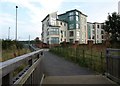
Flats, Long Down Avenue, Bristol
Looking up the short path mentioned at Image], with a footbridge in the foreground.
Image: © Derek Harper
Taken: 29 Sep 2014
0.12 miles
8
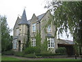
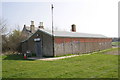
The Farmhouse at Stanley Farm
After lying derelict for many years, the farmhouse at Stanley Farm was restored as part of the MOD development at Abbey Wood. It now forms part of a training/conference facility.The main syndicate rooms are in the converted stable block which are off to the left (in the adjacent square)
Image: © Phil Williams
Taken: 30 Sep 2005
0.12 miles
9
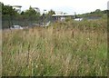
Waste land, Abbey Wood
Seen from a short path that connects the Cheswick development to footpath LSG/33 which runs alongside the government offices in the background.
Image: © Derek Harper
Taken: 29 Sep 2014
0.13 miles
10
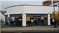
Boston Tea Party, Cheswick Village
Designer eatery in a 21st Century development on the border of Bristol and South Gloucestershire.
Image: © Jonathan Billinger
Taken: 4 Nov 2018
0.14 miles