IMAGES TAKEN NEAR TO
Canons Road, BRISTOL, BS1 5UH
Introduction
This page details the photographs taken nearby to Canons Road, BS1 5UH by members of the Geograph project.
The Geograph project started in 2005 with the aim of publishing, organising and preserving representative images for every square kilometre of Great Britain, Ireland and the Isle of Man.

There are currently over 7.5m images from over14,400 individuals and you can help contribute to the project by visiting https://www.geograph.org.uk
Image Map (Loading...)


Getting Data...Please wait
Leaflet Map data © OpenStreetMap
Images are licensed for reuse under creativecommons.org/licenses/by-sa/2.0
Notes
- Clicking on the map will re-center to the selected point.
- The higher the marker number, the further away the image location is from the centre of the postcode.
Image Listing (2151 Images Found)
Images are licensed for reuse under creativecommons.org/licenses/by-sa/2.0
Image
Details
Distance
1
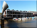
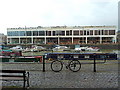
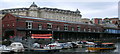
Za Za Bazaar, Bristol
World Banquet & Bar extending for 70 metres along the waterfront, viewed from Pero's Bridge. http://www.geograph.org.uk/photo/4407920
The structure resembling an oversized ear trumpet is a bridge counterweight.
Image: © Jaggery
Taken: 21 Oct 2012
0.00 miles
2
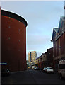
Canon's Road, Watershed and I-Max @t Bristol
Small road at the back of the Watershed - media centre converted from the old dock-side buildings on the right, and the back of the I-Max @t Bristol on the left.
In the distance is the Colston Tower.
Image: © Linda Bailey
Taken: 14 Feb 2006
0.01 miles
3
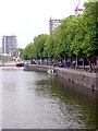
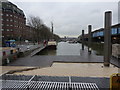
Looking up St Augustine's Reach
Looking north up St Augustine's Reach whilst standing on Pero's Bridge.
St Augustine's Reach was created by diverting the river Frome, originally in 1239.
Image: © Linda Bailey
Taken: 20 Jul 2006
0.01 miles
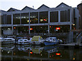
4
Looking across the inner harbour, Bristol
Image: © Eirian Evans
Taken: 23 Jun 2006
0.01 miles
5
Bristol, view from Broad Quay
City centre ferry landing
Image: © Peter Barr
Taken: 8 Feb 2010
0.01 miles
6
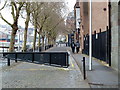
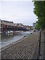
Narrow Quay, St Augustine's Reach, Bristol
Once Bristol's busiest commercial quayside, now largely given over to leisure and tourism. The Arnolfini arts centre is to the immediate right. The Floating Harbour here occupies the old course of the River Frome which used to be open to shipping well into the city centre but is now covered over by St Augustine's Parade.
Image: © Anthony O'Neil
Taken: 25 Jan 2011
0.01 miles
7
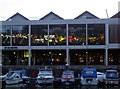
Eat your way around the world
Za Za Bazaar opened in late 2011 and has room for a thousand covers - making it the largest restaurant in Britain apparently. There are several 'islands' inside where fresh dishes are cooked, representing many different national flavours from around the world.
Image: © Neil Owen
Taken: 12 Jul 2017
0.01 miles
8
V-Shed at Bordeaux Quay, Bristol
No longer a 'transit shed' for holding cargo but a haven of eateries and bars which are thronged at weekends with young people and tourists.
Image: © Anthony O'Neil
Taken: 25 Jan 2011
0.01 miles
9
Water Taxi
Heading out of St Augustine's Reach, towards Pero's Bridge.
Image: © Thomas Nugent
Taken: 28 Sep 2010
0.02 miles
10
Za Za Bazaar
The restaurant is based on an old dockside warehouse; consequently, it boasts seating for a thousand and offers freshly-cooked dishes from all over the world. Inside is an equally diverse range of illuminated signage.
Image: © Neil Owen
Taken: 12 Jul 2017
0.02 miles