IMAGES TAKEN NEAR TO
Deanery Close, BRISTOL, BS15 9JL
Introduction
This page details the photographs taken nearby to Deanery Close, BS15 9JL by members of the Geograph project.
The Geograph project started in 2005 with the aim of publishing, organising and preserving representative images for every square kilometre of Great Britain, Ireland and the Isle of Man.

There are currently over 7.5m images from over14,400 individuals and you can help contribute to the project by visiting https://www.geograph.org.uk
Image Map
Images are licensed for reuse under creativecommons.org/licenses/by-sa/2.0
Notes
- Clicking on the map will re-center to the selected point.
- The higher the marker number, the further away the image location is from the centre of the postcode.
Image Listing (58 Images Found)
Images are licensed for reuse under creativecommons.org/licenses/by-sa/2.0
Image
Details
Distance
1
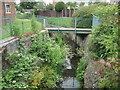
Warmley: Siston or Warmley Brook
Current Ordnance Survey maps, and all those from 1903 onwards, show this watercourse as Warmley Brook, eventually flowing into Siston Brook, but the 1882 OS map shows it as Siston Brook in this location. The old maps show a brook meandering through fields, but today it runs through a regular managed concrete channel. This is the view in Deanery Close.
Image: © Nigel Cox
Taken: 25 Jun 2011
0.01 miles
2
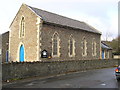
Warmley, South Gloucestershire, Congregational Church
Image: © ChurchCrawler
Taken: 27 Dec 2005
0.02 miles
3
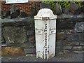
Old Boundary Marker by the A420, Deanery Road, Warmley
Parish Boundary Marker - Turnpike by the A420, in parish of Siston (South Gloucestershire District), Deanery Road, Warmley, at junction with Deanery Close, against garden wall.
Inscription reads:-
: BITTON / Pᴴ. : : 1823 / BRISTOL TURNPIKE TRUST : : SISTON / Pᴴ. :
Surveyed
Milestone Society National ID: GL_BRCP04pb
Image: © Milestone Society
Taken: Unknown
0.03 miles
4
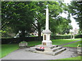
Warmley: The War Memorial
Set in the centre of the Memorial Gardens, Warmley's War Memorial is a Grade II Listed Structure.
Image: © Nigel Cox
Taken: 25 Jun 2011
0.04 miles
5
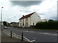
Warmley War Memorial Hall
On Deanery Road.
Image: © Mike Faherty
Taken: 19 Jul 2011
0.05 miles
6
2009 : A420 High Street, Warmley
Tower Road to the left, Stanley Road to the right, up the hill to Kingswood straight on.
The advertisement is for Raleigh and Humber bicycles.
Image: © Maurice Pullin
Taken: 12 Oct 2009
0.06 miles
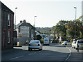
7

Stanley Road at the junction of London Road
Image: © David Howard
Taken: 1 Jun 2019
0.06 miles
8
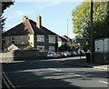
2009 : A4175 Stanley Road at Warmley
Joins the A420 immediately behind the camera position.
In this direction the A4175 passes over Siston Common, skirts around New Cheltenham and ends at Staple Hill, probably because it runs out of things to do.
Image: © Maurice Pullin
Taken: 12 Oct 2009
0.07 miles
9

Humber and Raleigh Old Advertisement
Found on the A420 corner of Tower Road North, Warmley, Bristol, and still in good condition in April 2018
Image: © Rick Crowley
Taken: 15 Oct 2011
0.07 miles
10
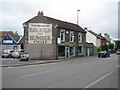
Warmley: Webb's of Warmley and the A420 High Street
The old painted sign on the wall may appear to be a relic of a bygone age, but it is pleasing to relate that the shop is Webb's of Warmley, the local cycle dealers. The road is the A420 looking towards Bristol.
Image: © Nigel Cox
Taken: 25 Jun 2011
0.08 miles