IMAGES TAKEN NEAR TO
Ridgeway Lane, BRISTOL, BS14 9QU
Introduction
This page details the photographs taken nearby to Ridgeway Lane, BS14 9QU by members of the Geograph project.
The Geograph project started in 2005 with the aim of publishing, organising and preserving representative images for every square kilometre of Great Britain, Ireland and the Isle of Man.

There are currently over 7.5m images from over14,400 individuals and you can help contribute to the project by visiting https://www.geograph.org.uk
Image Map (Loading...)


Getting Data...Please wait
Leaflet Map data © OpenStreetMap
Images are licensed for reuse under creativecommons.org/licenses/by-sa/2.0
Notes
- Clicking on the map will re-center to the selected point.
- The higher the marker number, the further away the image location is from the centre of the postcode.
Image Listing (31 Images Found)
Images are licensed for reuse under creativecommons.org/licenses/by-sa/2.0
Image
Details
Distance
1
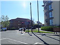
Traffic lights at the junction of Wells Road and Ridgeway Lane
Image: © Eirian Evans
Taken: 11 Apr 2019
0.02 miles
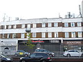
2
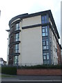
The Ridge on Ridgeway Lane
A new block of apartments now stands on the site of a garage. The old forecourt would sometimes be used by impatient drivers as they could use it to bypass the traffic lights at the junction. Not any more.
Image: © Neil Owen
Taken: 7 May 2020
0.02 miles
3
A trolley on the run
An Asda trolley seems to have taken cover. Perhaps it doesn't want to go back to the grind.
Image: © Neil Owen
Taken: 29 Apr 2020
0.06 miles
4
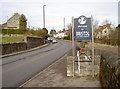
Welcome to Bristol
The more up to date version of the boundary sign; see Image] for a 1950s utilitarian concrete job.
Image: © Neil Owen
Taken: 14 Feb 2012
0.06 miles
5
Gilda Parade is gilded with masts
The long rooftop of the shopping rank was too much of an opportunity to miss for the mobile telephone providers.
Image: © Neil Owen
Taken: 7 May 2020
0.09 miles
6
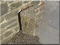
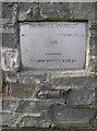
Old Boundary Marker by the A37, Bristol Road, Whitchurch
County Boundary Marker by the A37, in parish of Whitchurch (Bath and North East Somerset District), Bristol Road, Northern end of Saltwell Viaduct, just South of junction with Wells Close.
Inscription reads vertically:-
: SOMERSET : : 1951 : BRISTOL :
Surveyed
Milestone Society National ID: SO_SSBR01cb
Image: © Milestone Society
Taken: Unknown
0.09 miles
7
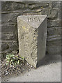
County boundary stone
It used to be the divisor between Bristol and Somerset, but now it marks the boundary of Bristol and BaNES. How times (and politics) have changed since 1951. See Image] for a more modern approach to signage.
Image: © Neil Owen
Taken: 14 Feb 2012
0.09 miles
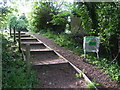
8
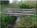
A sturdy crossing
A fine wooden footbridge in the area downstream from the Saltwell Viaduct. Keen observers will have decided that it was not built in 2019, nor built by Lilly.
Image: © Neil Owen
Taken: 29 Apr 2020
0.10 miles
9
Saltwell Viaduct - Rebuilt
The large bridge that carries the main A37 Wells Road over the small stream below was extensively rebuilt. This plaque gives the details. See Image] for a look down the back.
Image: © Neil Owen
Taken: 14 Feb 2012
0.11 miles
10
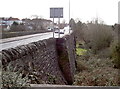
Saltwell Viaduct
The other side of the viaduct, showing the height above the stream.
Image: © Neil Owen
Taken: 14 Feb 2012
0.11 miles