IMAGES TAKEN NEAR TO
Hazelbury Road, BRISTOL, BS14 9EU
Introduction
This page details the photographs taken nearby to Hazelbury Road, BS14 9EU by members of the Geograph project.
The Geograph project started in 2005 with the aim of publishing, organising and preserving representative images for every square kilometre of Great Britain, Ireland and the Isle of Man.

There are currently over 7.5m images from over14,400 individuals and you can help contribute to the project by visiting https://www.geograph.org.uk
Image Map
Images are licensed for reuse under creativecommons.org/licenses/by-sa/2.0
Notes
- Clicking on the map will re-center to the selected point.
- The higher the marker number, the further away the image location is from the centre of the postcode.
Image Listing (20 Images Found)
Images are licensed for reuse under creativecommons.org/licenses/by-sa/2.0
Image
Details
Distance
1

Bristol townscape from above
Looking north along the line of the A37 into Bristol from the south, from over Whitchurch. The obvious school, lower left, is the Oasis Academy John Williams, a secondary school http://www.oasisacademyjohnwilliams.org/.
Image: © M J Richardson
Taken: 23 Dec 2015
0.08 miles
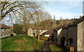
2
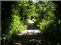
Former railway line at Stockwood
Now part of National Cycle Network path 3, this stretch of former railway line runs parallel to Sturminster Road.
Image: © Derek Harper
Taken: 3 Jun 2006
0.11 miles
3
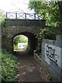
Over and under the old railway bridge
The former Bristol and North Somerset Line bridge is all that remains of the route, which is now a foot and cycle path.
Image: © Neil Owen
Taken: 12 May 2022
0.14 miles
4
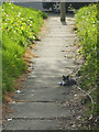
A cat nap on the path
A moggy takes some time out in the warm Spring sunshine. With the nation in lockdown it must think it's a good thing that there aren't many people about to disturb the peace.
Image: © Neil Owen
Taken: 26 Apr 2020
0.17 miles
5
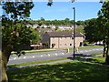
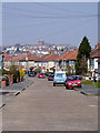
Sturminster Road
Housing at Stockwood, seen across the busy but unclassified road.
Image: © Derek Harper
Taken: 3 Jun 2006
0.17 miles
6
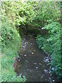
Bridge at Linnet Way
An early incarnation of the Brislington Brook as it passes under the bridge.
Image: © Neil Owen
Taken: 26 Apr 2020
0.18 miles
7
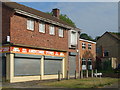
Amercombe Stores
A local corner shop, with some typical 1950-60s architecture. The shop appears to have the keepers' residence directly above the premises, with a stylish balcony to boot.
Image: © Neil Owen
Taken: 26 Apr 2020
0.19 miles
8
Houses by Sturminster Road, Bristol
A green space between Hanford Court (right) and Durweston Court.
Image: © Derek Harper
Taken: 10 Mar 2018
0.20 miles
9
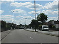
The dual carriageway Wells Road through Hengrove
Image: © Sarah Charlesworth
Taken: 16 Aug 2010
0.20 miles
10
Looking along Kinsale Road
Looking towards Knowle.
Image: © Linda Bailey
Taken: 26 Mar 2007
0.21 miles