IMAGES TAKEN NEAR TO
Long Eaton Drive, BRISTOL, BS14 9AW
Introduction
This page details the photographs taken nearby to Long Eaton Drive, BS14 9AW by members of the Geograph project.
The Geograph project started in 2005 with the aim of publishing, organising and preserving representative images for every square kilometre of Great Britain, Ireland and the Isle of Man.

There are currently over 7.5m images from over14,400 individuals and you can help contribute to the project by visiting https://www.geograph.org.uk
Image Map
Images are licensed for reuse under creativecommons.org/licenses/by-sa/2.0
Notes
- Clicking on the map will re-center to the selected point.
- The higher the marker number, the further away the image location is from the centre of the postcode.
Image Listing (32 Images Found)
Images are licensed for reuse under creativecommons.org/licenses/by-sa/2.0
Image
Details
Distance
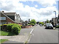
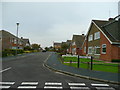
1
Coming off the bend
Knowle Speedway and Greyhound stadium was first opened here in the late 1920s. Despite a war causing some interference, the tracks were in good use well into the 1950s. At that time, this spot would have been the end of the south bend before riders roared past the stands and clubhouse to the right of shot.
The track closed in 1961 and this housing development has erased almost all trace.
Image: © Neil Owen
Taken: 19 May 2022
0.01 miles
2
Starting and finishing at Edgewood Close
This short road is a cul-de-sac in the post-war estate. But a few years prior to the construction, this was the old Knowle Speedway and Greyhound stadium. Although there is no trace now, this spot was around the start and finish line in front of the main stand.
Image: © Neil Owen
Taken: 19 May 2022
0.04 miles
3

A wall on Petherton Road
The wall is mainly modern and but the pier of darker bricks in between them holds a benchmark from the original construction of the school. See Image
Image: © Neil Owen
Taken: 19 May 2022
0.06 miles
4
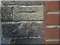
Benchmark on a wall on Petherton Road
The wall is from around the Second World War period and this benchmark was on a school premises originally. See https://www.bench-marks.org.uk/bm102030 for the entry in the Benchmark Database and Image] for a wider view.
Image: © Neil Owen
Taken: 19 May 2022
0.06 miles
5
A faceful of gravel
Today this is a quiet suburban neighbourhood with lots of 1960s housing. But if you were stood around here in the 1950s you would be risking a faceful of gravel. At that time, this spot was part of the old Knowle speedway track, and also where the greyhound track joined the west straight.
Image: © Neil Owen
Taken: 19 May 2022
0.07 miles
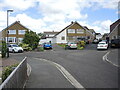
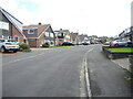
6
Allanmead Road
Looking north-east from Long Eaton Drive, Hengrove.
Image: © Jonathan Billinger
Taken: 4 Nov 2008
0.07 miles
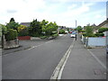
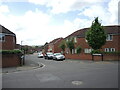
7
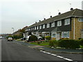
Long Eaton Drive
Typical housing of this part of Hengrove, South Bristol.
Image: © Jonathan Billinger
Taken: 4 Nov 2008
0.07 miles
8
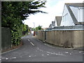
Un-named road off Eaton Drive
Running along the back of the houses that face the Wells Road is a narrow tarmac lane. It was built slightly later than the majority of houses the area.
Image: © Neil Owen
Taken: 19 May 2022
0.08 miles
9
At the back of the stands
Ravenhead Drive lies largely across the site of the old Knowle speedway track. Just after the war this site would have been a packed stand, some offices and kennels.
Image: © Neil Owen
Taken: 19 May 2022
0.08 miles
10
John Hall Close
A modern housing development that stands on the site of the former Petherton Road School. It split into juniors and infants schools in 1949, but finally closed in the 1980s. As an aside, Petherton Road was originally known as Back Lane before the houses were built.
Image: © Neil Owen
Taken: 19 May 2022
0.08 miles