IMAGES TAKEN NEAR TO
Ladman Road, BRISTOL, BS14 8QF
Introduction
This page details the photographs taken nearby to Ladman Road, BS14 8QF by members of the Geograph project.
The Geograph project started in 2005 with the aim of publishing, organising and preserving representative images for every square kilometre of Great Britain, Ireland and the Isle of Man.

There are currently over 7.5m images from over14,400 individuals and you can help contribute to the project by visiting https://www.geograph.org.uk
Image Map
Images are licensed for reuse under creativecommons.org/licenses/by-sa/2.0
Notes
- Clicking on the map will re-center to the selected point.
- The higher the marker number, the further away the image location is from the centre of the postcode.
Image Listing (48 Images Found)
Images are licensed for reuse under creativecommons.org/licenses/by-sa/2.0
Image
Details
Distance
1
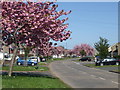
Stockwood Road in bloom
It's Easter Monday, 2020, and the mid-April weather has been very sunny - just the job to bring out the blossom.
Image: © Neil Owen
Taken: 13 Apr 2020
0.05 miles
2
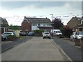
Merriment in Meardon Road
Some bunting for the next day's VE 75 celebrations.
Image: © Neil Owen
Taken: 7 May 2020
0.12 miles
3
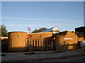
Stockwood Library
One of Bristol's younger libraries, featuring some modern architecture.
Image: © Neil Owen
Taken: 28 Oct 2011
0.15 miles
4
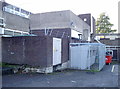
Electricity substation, Stockwood
Looking rather sternly defended and forming a wall of reinforcement with other apparatus, this modest utility has a benchmark: Image
Image: © Neil Owen
Taken: 28 Oct 2011
0.16 miles
5
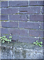
Benchmark on electricity substation
Part of Stockwood shopping centre, with a substation to the rear of the shops and in the carpark. This cutmark is listed in the Database: http://www.bench-marks.org.uk/bm39858 , and is a mere youngster having been made in 1978. See Image] for a wider view.
Image: © Neil Owen
Taken: 28 Oct 2011
0.16 miles
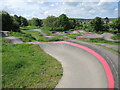
6
Track builders
The new pump track in Stockwood was designed by Architrail Velosolutions for use by bikes, skateboards and scooters.
Image: © Neil Owen
Taken: 12 May 2022
0.17 miles
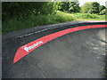
7
Bumps behind Burnbush School
A new cycle track has opened in the open space off Whittock Road, not far from the school (which is now known as Woodlands Academy).
Image: © Neil Owen
Taken: 12 May 2022
0.18 miles
8
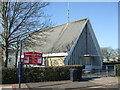
Stockwood Free Church
The Baptist church was constructed as the first of the new houses were being built, and was part of the original plans when Stockwood grew up from Sturminster Road. Despite the problems caused in the terrible winter of 1963, the church was completed and a ceremonial opening held on Saturday 7th December that year.
Image: © Neil Owen
Taken: 28 Feb 2021
0.18 miles
9
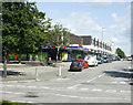
2009 : Post Office and shops, Stockwood
At the junction of Stockwood Road and Hollway Road.
Image: © Maurice Pullin
Taken: 7 Aug 2009
0.18 miles
10
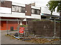
Dangerous wall
This wall is so dangerous, it has had to be kept behind a fence to stop it attacking unwary shoppers.
Image: © Neil Owen
Taken: 29 Sep 2017
0.19 miles