IMAGES TAKEN NEAR TO
Isabella Road, BRISTOL, BS14 0BF
Introduction
This page details the photographs taken nearby to Isabella Road, BS14 0BF by members of the Geograph project.
The Geograph project started in 2005 with the aim of publishing, organising and preserving representative images for every square kilometre of Great Britain, Ireland and the Isle of Man.

There are currently over 7.5m images from over14,400 individuals and you can help contribute to the project by visiting https://www.geograph.org.uk
Image Map
Images are licensed for reuse under creativecommons.org/licenses/by-sa/2.0
Notes
- Clicking on the map will re-center to the selected point.
- The higher the marker number, the further away the image location is from the centre of the postcode.
Image Listing (8 Images Found)
Images are licensed for reuse under creativecommons.org/licenses/by-sa/2.0
Image
Details
Distance
1
Bus Stop and Houses on Bamfield
This is the Alverstoke bus stop on Bamfield next to the small residential cul de sac known as Alverstoke
Image: © Nigel Mykura
Taken: 25 Dec 2021
0.16 miles
2
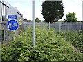
No bikes in school
An old pedestrian entrance to the old Hengrove School is now firmly fenced off. The overgrowing brambles are an extra touch to prevent egress, either on foot or wheels.
Image: © Neil Owen
Taken: 19 May 2022
0.16 miles
3
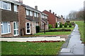
Front of Houses on Swainswick
There is no road in front of these houses whose rear backs on to Swainswick. They face a small green area that leads from Bamfield through to Hengrove Park whcich can be seen in the distance.
Image: © Nigel Mykura
Taken: 25 Dec 2021
0.19 miles
4
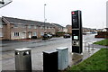
A walk to work
The Airport Road is now much changed as the large high-rise homes are being built.
Image: © Neil Owen
Taken: 12 May 2022
0.22 miles
5
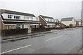
Houses on Bamfield
A wet dreary day on Bamfield. These semi detached houses are between Clydesdale Close and Maes Knoll Close.
Image: © Nigel Mykura
Taken: 25 Dec 2021
0.23 miles
6
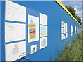
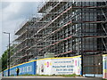
Appealing to future buyers
The new houses going up on Airport Road have long hoardings. In one particular spot, the boards are covered with contributions from local primary schoolchildren. Quite what the developers expect from the coloured in drawings in open to speculation. Maybe they will be customers of the next generations.
Image: © Neil Owen
Taken: 12 May 2022
0.23 miles
7
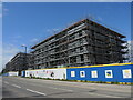
Bo Klok on the Brook
A long strip of grassland runs beside the brook through this part of Knowle, also marking what became the Airport Road. Having missed the large housing development after WWI, the land has finally been allotted housing development of its own. The developers are a partnership between Skanska and IKEA, and are building a large number of high-density homes for various sorts of owners.
Image: © Neil Owen
Taken: 12 May 2022
0.24 miles
8
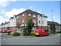
Shops on Loxton Square
The old single-storey concrete row of shops was demolished a few years ago and this much larger store and post office created. Extra space has been consumed by new houses too.
Image: © Neil Owen
Taken: 19 May 2022
0.25 miles