IMAGES TAKEN NEAR TO
Armada Place, BRISTOL, BS1 3SF
Introduction
This page details the photographs taken nearby to Armada Place, BS1 3SF by members of the Geograph project.
The Geograph project started in 2005 with the aim of publishing, organising and preserving representative images for every square kilometre of Great Britain, Ireland and the Isle of Man.

There are currently over 7.5m images from over14,400 individuals and you can help contribute to the project by visiting https://www.geograph.org.uk
Image Map (Loading...)


Getting Data...Please wait
Leaflet Map data © OpenStreetMap
Images are licensed for reuse under creativecommons.org/licenses/by-sa/2.0
Notes
- Clicking on the map will re-center to the selected point.
- The higher the marker number, the further away the image location is from the centre of the postcode.
Image Listing (405 Images Found)
Images are licensed for reuse under creativecommons.org/licenses/by-sa/2.0
Image
Details
Distance
1
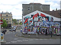
Colour on Nine Tree Hill
Close to the city centre, this area of Bristol can claim to have much more street art.
Image: © Neil Owen
Taken: 25 Apr 2019
0.02 miles
2
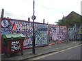
Dove Street gallery
Plenty of opportunity for the spray can artists to play.
Image: © Neil Owen
Taken: 25 Apr 2019
0.02 miles
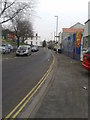
3
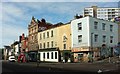
Stokes Croft
Buildings on the west side of the A38 between the junctions with Jamaica Street and Nine Tree Hill (right). The second and third premises along from the latter form the former Swan Inn "Inn, now club. c1711, C19 front" https://www.historicengland.org.uk/listing/the-list/list-entry/1282098 .
Image: © Derek Harper
Taken: 26 Jun 2017
0.02 miles
4
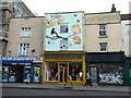
Treasure, Stokes Croft
A boutique charity shop raising funds for the local area. Also featuring a beautiful mural
Image: © Eirian Evans
Taken: 19 Feb 2018
0.02 miles
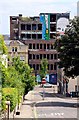
5
No sign at the old carriageworks
The old frontage of Perry's carriageworks is to be retained (whilst the rest of the factory has gone now), with a new use being sought. But plans and actions seem to be in great disassociation.
Image: © Neil Owen
Taken: 11 Oct 2022
0.02 miles
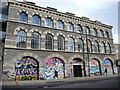
6
Armada Place
The mix of run-down 20th century buildings and elegant 18th century ones is characteristic of the area, as is the vibrant graffiti.
Image: © HelenK
Taken: 13 Mar 2012
0.03 miles
7
Looking down Ninetree Hill to Westmoreland House
Image: © Steve Daniels
Taken: 2 Jun 2011
0.03 miles
8
Hooper House Cafe, Stokes Croft
Hooper House Cafe (formerly Kuvula Cafe) takes its name from the original occupants of the building over 100 years ago. In those days it was W.J.Hooper’s Fish and Poultry Market.
Image: © Eirian Evans
Taken: 29 Jul 2011
0.03 miles
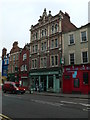
9
Former ironmonger's, Stokes Croft
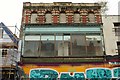
The former Palmer's Hardware & Ironmongery shop, "established 1868" on the west side of the A38. And indeed the datestone at the top also says 1868. More recently this building was an electrical store, but it now seems to be disused.
Image: © Derek Harper
Taken: 9 Oct 2017
0.03 miles
10
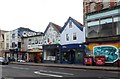
Colourful shop fronts in Stokes Croft
Image: © Eirian Evans
Taken: 19 Feb 2018
0.03 miles