IMAGES TAKEN NEAR TO
Lamington Close, BRISTOL, BS13 8EJ
Introduction
This page details the photographs taken nearby to Lamington Close, BS13 8EJ by members of the Geograph project.
The Geograph project started in 2005 with the aim of publishing, organising and preserving representative images for every square kilometre of Great Britain, Ireland and the Isle of Man.

There are currently over 7.5m images from over14,400 individuals and you can help contribute to the project by visiting https://www.geograph.org.uk
Image Map (Loading...)


Getting Data...Please wait
Leaflet Map data © OpenStreetMap
Images are licensed for reuse under creativecommons.org/licenses/by-sa/2.0
Notes
- Clicking on the map will re-center to the selected point.
- The higher the marker number, the further away the image location is from the centre of the postcode.
Image Listing (14 Images Found)
Images are licensed for reuse under creativecommons.org/licenses/by-sa/2.0
Image
Details
Distance
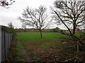
1
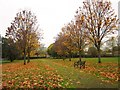
King's Head Lane Park, Bishopsworth
A tree-lined path. By the time you've passed the third tree on the right, you're in Image
Image: © Derek Harper
Taken: 16 Nov 2013
0.06 miles
2
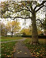
Kings Head Park, Bishopsworth
Seen from the entrance of footpath BCC/493 near Home Farm.
Image: © Derek Harper
Taken: 16 Nov 2013
0.08 miles
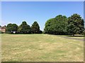
3
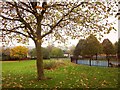
King's Head Lane Park, Bishopsworth
The playground on the right was completed in 2009. The park is mapped as King's Head Park but seems to be known as King's Head Lane Park.
Image: © Derek Harper
Taken: 16 Nov 2013
0.09 miles
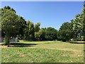
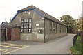
5
Recreation ground, Highridge
This is the home of Highridge United Football Club. Taken from public footpath BCC/488, which run around the eastern side of the sports ground. On the left is a fence surrounding St Peter's school.
Image: © Derek Harper
Taken: 16 Nov 2013
0.13 miles
7
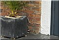
Ordnance Survey Cut Mark
This OS cut mark can be found on No29 Tugela Road. It marks a point 61.320m above mean sea level.
Image: © Adrian Dust
Taken: 5 Aug 2022
0.16 miles
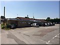
10
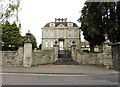
Building beside St Peter's Church, Bishopsworth
This building is mapped as "Council Offices"; whether they are still used as such I haven't been able to determine.
Image: © Derek Harper
Taken: 16 Nov 2013
0.23 miles