IMAGES TAKEN NEAR TO
Perrycroft Road, BRISTOL, BS13 7RY
Introduction
This page details the photographs taken nearby to Perrycroft Road, BS13 7RY by members of the Geograph project.
The Geograph project started in 2005 with the aim of publishing, organising and preserving representative images for every square kilometre of Great Britain, Ireland and the Isle of Man.

There are currently over 7.5m images from over14,400 individuals and you can help contribute to the project by visiting https://www.geograph.org.uk
Image Map (Loading...)


Getting Data...Please wait
Leaflet Map data © OpenStreetMap
Images are licensed for reuse under creativecommons.org/licenses/by-sa/2.0
Notes
- Clicking on the map will re-center to the selected point.
- The higher the marker number, the further away the image location is from the centre of the postcode.
Image Listing (32 Images Found)
Images are licensed for reuse under creativecommons.org/licenses/by-sa/2.0
Image
Details
Distance
1
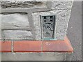
Ordnance Survey Flush Bracket (84)
This OS Flush Bracket can be found on No21 Whitchurch Lane. It marks a point 43.970m above mean sea level.
Image: © Adrian Dust
Taken: 28 Sep 2023
0.10 miles
2
Flush Bracket, Whitchurch Road
A flush bracket, on the Upton Lovell to Flax Bourton levelling line and dating from the early twentieth century period, located on a cottage in south-west Bristol. See http://www.bench-marks.org.uk/bm2689 for the entry in the Benchmark Database and details about number 84.
Image: © Neil Owen
Taken: 4 Feb 2013
0.10 miles
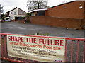
3
No splash
Bishopsworth swimming pool, now closed and with no immediate future. Having operated for nearly forty years a newer and bigger pool opened just a few miles away; the council found they could no longer justify the cost of running it.
The site was once a chapel in the twelfth century, which was converted into cottages in the sixteenth. They were demolished in 1961 to make way for the pool. What it will be in the future is open to debate.
See Image] for another view.
Image: © Neil Owen
Taken: 4 Feb 2013
0.11 miles
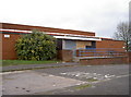
4
A new kingdom
The Jehovah's Witnesses have a nice new hall to gather in, completely replacing the smaller hall on the same site. See Dr Duncan Pepper's 2009 shot to compare - Image
Image: © Neil Owen
Taken: 4 Feb 2013
0.12 miles
5
A dry future?
The baths have been a popular venue for the local people since it opened in the 1970s. However, once Hengrove Leisure Centre opened with its olympic sized 50m pool the council immediately shut Bishopsworth. See Image] for another view.
Image: © Neil Owen
Taken: 4 Feb 2013
0.12 miles
6
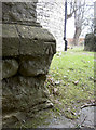
Benchmark facing the path
A benchmark, as listed in the Benchmark Database: http://www.bench-marks.org.uk/bm47097 , on St Peter's church, Bishopsworth. Presumably it was a more open area when it was cut, but now it is in the shadows thanks to some dense hedging opposite it. See Image] for more views of the old church.
Image: © Neil Owen
Taken: 4 Feb 2013
0.13 miles
7
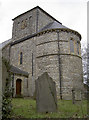
St Peter's church, Bishopsworth
This uncommonly styled church lies in the heart of the suburb of Bishopsworth in southwest Bristol.
Originally there was a chapel dating back to the twelfth century dedicated to St Peter and St Paul, almost directly opposite the current church, on what is now the disused swimming pool (see Image]). That chapel was converted into three cottages in 1540. However, the growing local population sought a church of their own.
Despite the area being one of poor agricultural labourers and miners, the £1500 needed was raised. In fact, most of the money came from outside the area and a slight shortfall demanded that the belfry's original design was reduced to the present (and perhaps more appropriate) version.
St Peter's was designed by the eminent architect Samuel Charles Fripp and opened in 1842; the finished church was consecrated by the Bishop of Salisbury on the 22nd April 1843. It is now a Grade II* listed building and the intriguing style is a fine example of the Norman Revival of the 1840s.
See Image] for more views, including a benchmark - Image
Image: © Neil Owen
Taken: 4 Feb 2013
0.13 miles
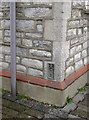
8
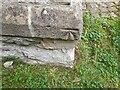
Ordnance Survey Cut Mark
This OS cut mark can be found on the SE angle of St Peter's Church. It marks a point 47.948m above mean sea level.
Image: © Adrian Dust
Taken: 28 Sep 2023
0.13 miles
9
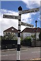
Direction Sign ? Signpost
Located on the south side of the Y junction of Church Road and Grange Road in Bishopsworth, Bristol. 4 arms, 1 missing, and pyramid finial. For an older photo see https://www.geograph.org.uk/photo/6049110.
Milestone Society National ID: SO_ST5768
Image: © S Kosciow
Taken: 26 Apr 2019
0.13 miles
10
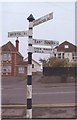
Old Direction Sign - Signpost in Bishopsworth, Bristol parish
Pyramid finial - 4 arms; Somerset SCC pyramid by the UC road, in parish of Bristol (City of Bristol District), Bishopsworth; junction of Church Road with Grange Road.
To be surveyed
Milestone Society National ID: SO_ST5768
Image: © Milestone Society
Taken: Unknown
0.13 miles