IMAGES TAKEN NEAR TO
Hillyfield Road, BRISTOL, BS13 7QF
Introduction
This page details the photographs taken nearby to Hillyfield Road, BS13 7QF by members of the Geograph project.
The Geograph project started in 2005 with the aim of publishing, organising and preserving representative images for every square kilometre of Great Britain, Ireland and the Isle of Man.

There are currently over 7.5m images from over14,400 individuals and you can help contribute to the project by visiting https://www.geograph.org.uk
Image Map (Loading...)


Getting Data...Please wait
Leaflet Map data © OpenStreetMap
Images are licensed for reuse under creativecommons.org/licenses/by-sa/2.0
Notes
- Clicking on the map will re-center to the selected point.
- The higher the marker number, the further away the image location is from the centre of the postcode.
Image Listing (31 Images Found)
Images are licensed for reuse under creativecommons.org/licenses/by-sa/2.0
Image
Details
Distance
1
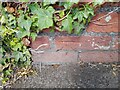
Ordnance Survey Cut Mark
This OS cut mark can be found on the wall NW side of St Peters Rise. It marks a point 38.316m above mean sea level.
Image: © Adrian Dust
Taken: 5 Aug 2022
0.11 miles
2
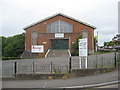
Crossways Tabernacle, Headley Park
Image: © Dr Duncan Pepper
Taken: 18 Jun 2009
0.12 miles
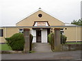
3

Headley Park Church
This post-war estate's church was originally the Crossway Tabernacle. However, the problem of dwindling congregations was addressed when they merged with the Kensington Baptist Church in 2007. The building also received a make-over.
Image: © Neil Owen
Taken: 31 May 2014
0.12 miles
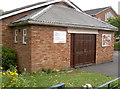
4
Hall open today
Headley Park community centre has occupants.
Image: © Neil Owen
Taken: 31 May 2014
0.12 miles

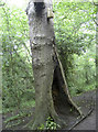
6
Your roots are showing
A tree clings onto the steep, eroded banks above the Malago. Any more soil loss and it will end up in the drink.
Image: © Neil Owen
Taken: 15 Feb 2012
0.13 miles
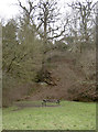
7
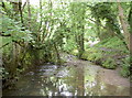
The Malago re-emerges
The top of the Manor Woods open space is a shady glade where the stream appears after running underground.
Image: © Neil Owen
Taken: 31 May 2014
0.14 miles
8
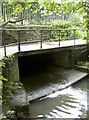
The Malago ducks
From its source a mile or so away, the Malago runs under the road of St Peters Rise before carrying down the valley.
Image: © Neil Owen
Taken: 31 May 2014
0.14 miles
9
Burnt heart
Several of the trees in this valley have been subject to burning, fashioning a hollow. Hopefully the bird box was not occupied at the time.
Image: © Neil Owen
Taken: 31 May 2014
0.14 miles
10
Scouts' hut
Next to the old tabernacle in St Peters Rise.
Image: © Neil Owen
Taken: 31 May 2014
0.15 miles