IMAGES TAKEN NEAR TO
Ilchester Crescent, BRISTOL, BS13 7HW
Introduction
This page details the photographs taken nearby to Ilchester Crescent, BS13 7HW by members of the Geograph project.
The Geograph project started in 2005 with the aim of publishing, organising and preserving representative images for every square kilometre of Great Britain, Ireland and the Isle of Man.

There are currently over 7.5m images from over14,400 individuals and you can help contribute to the project by visiting https://www.geograph.org.uk
Image Map
Images are licensed for reuse under creativecommons.org/licenses/by-sa/2.0
Notes
- Clicking on the map will re-center to the selected point.
- The higher the marker number, the further away the image location is from the centre of the postcode.
Image Listing (62 Images Found)
Images are licensed for reuse under creativecommons.org/licenses/by-sa/2.0
Image
Details
Distance
1
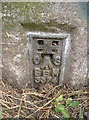
Trig Pillar, Bristol
Flush bracket for the Ilchester Crescent station, overlooking southwest Bristol
Image: © Neil Owen
Taken: 10 Jul 2010
0.05 miles
2
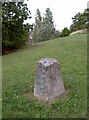
Trig Pillar, Bristol
Officially the Ilchester Crescent station, this little chap has suffered not only from vandalism, but the foliage has now surrounded it. My father pointed me in the direction of this one as he grew up just a stone's throw from it. Clearly, it has been standing here for many years and has probably seen much change since before the war.
Image: © Neil Owen
Taken: 10 Jul 2010
0.05 miles
3
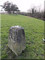
Triangulation Pillar
Ordnance Survey triangulation pillar showing vandalism damage.
Image: © Mat Tuck
Taken: 2 Mar 2013
0.06 miles
4
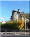
Unusual House on Bedminster Down Road
Image: © Anthony Parkes
Taken: 7 Apr 2015
0.09 miles
5
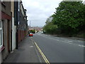
Bridgwater Road (A38), Bedminster Down
Heading north east into Bristol.
Image: © JThomas
Taken: 10 May 2013
0.11 miles
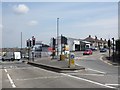
8
The A38 takes you both ways
Take your pick of west or south. A view from the brick-built railway bridge over the main southwest destinations. A benchmark is cut into the courses - see Image
Image: © Neil Owen
Taken: 19 Dec 2011
0.14 miles
9
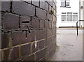
Benchmark on the A38 bridge
The bricks are part of the railway bridge built in 1933 - the A38 road carries over the important tracks below. The cutmark is listed in the Benchmark Database: http://www.bench-marks.org.uk/bm40585 . See Image] for a broader view.
Image: © Neil Owen
Taken: 19 Dec 2011
0.14 miles
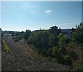
10
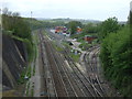
Railway junction near Bedminster
Looking south west from Bedminster Down Road.
Image: © JThomas
Taken: 10 May 2013
0.14 miles