IMAGES TAKEN NEAR TO
BS11 9PJ
Introduction
This page details the photographs taken nearby to BS11 9PJ by members of the Geograph project.
The Geograph project started in 2005 with the aim of publishing, organising and preserving representative images for every square kilometre of Great Britain, Ireland and the Isle of Man.

There are currently over 7.5m images from over14,400 individuals and you can help contribute to the project by visiting https://www.geograph.org.uk
Image Map
Images are licensed for reuse under creativecommons.org/licenses/by-sa/2.0
Notes
- Clicking on the map will re-center to the selected point.
- The higher the marker number, the further away the image location is from the centre of the postcode.
Image Listing (61 Images Found)
Images are licensed for reuse under creativecommons.org/licenses/by-sa/2.0
Image
Details
Distance
1
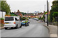
Crossroads in Shirehampton
Kings Weston Avenue meets Lower High Street. In the background, you can see the M5 as it crosses the River Avon.
Image: © Bill Boaden
Taken: 27 Sep 2017
0.02 miles
2
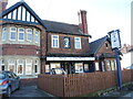
The Hope and Anchor
A turn-of-the-1900s pub in the Lower High Street (if that's not an oxymoron). See Image] for a closer look at the relief and Image] for a benchmark.
Image: © Neil Owen
Taken: 6 Feb 2023
0.04 miles
3
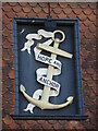
A good sign
The Hope and Ancor sign is a relief creation set into the upper floor wall of the pub. See Image] for a wider view.
Image: © Neil Owen
Taken: 6 Feb 2023
0.04 miles
4
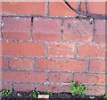
Ordnance Survey Cut Mark
This OS cut mark can be found on The Hope & Anchor, Lower High Street. It marks a point 9.613m above mean sea level.
Image: © Adrian Dust
Taken: 12 Mar 2020
0.05 miles
5
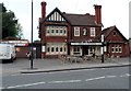
Hope & Anchor, Shirehampton, Bristol
Pub at 75 Lower High Street, Shirehampton.
Image: © Jaggery
Taken: 23 Jun 2012
0.05 miles
6
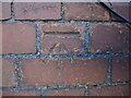
Benchmark on the Hope and Anchor
A modern cutmark, as listed in the Benchmark Database: https://www.bench-marks.org.uk/bm79411 , on the front of the pub. See Image] for a wider view.
Image: © Neil Owen
Taken: 6 Feb 2023
0.05 miles
7
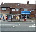
Triangle Television, Shirehampton, Bristol
The shop is at 79 Lower High Street, Shirehampton. Viewed from the corner of Shire Gardens.
Image: © Jaggery
Taken: 23 Jun 2012
0.07 miles
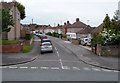
8
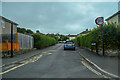
Shirehampton : Old Quarry Road
Looking along Old Quarry Road off Kings Weston Avenue.
Image: © Lewis Clarke
Taken: 8 Sep 2020
0.07 miles
9
Old Park Road, Shirehampton, Bristol
Viewed across Lower High Street.
Image: © Jaggery
Taken: 23 Jun 2012
0.08 miles
10
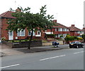
Lower High Street houses, Shirehampton, Bristol
Viewed from the corner of Penpole Lane.
The strange looking object between the tree and the car is a motorbike with a protective covering.
Image: © Jaggery
Taken: 23 Jun 2012
0.08 miles