IMAGES TAKEN NEAR TO
St. Andrews Road, BRISTOL, BS11 9BY
Introduction
This page details the photographs taken nearby to St. Andrews Road, BS11 9BY by members of the Geograph project.
The Geograph project started in 2005 with the aim of publishing, organising and preserving representative images for every square kilometre of Great Britain, Ireland and the Isle of Man.

There are currently over 7.5m images from over14,400 individuals and you can help contribute to the project by visiting https://www.geograph.org.uk
Image Map
Images are licensed for reuse under creativecommons.org/licenses/by-sa/2.0
Notes
- Clicking on the map will re-center to the selected point.
- The higher the marker number, the further away the image location is from the centre of the postcode.
Image Listing (43 Images Found)
Images are licensed for reuse under creativecommons.org/licenses/by-sa/2.0
Image
Details
Distance
2
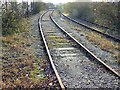
Disused railway line, King's Weston Lane, Avonmouth
Still in situ but no longer used, the line used to serve the chemical complex that takes up most of the square. The main company here, Rhodia, is to cease production here in 2008 ending a production history that began in 1917. More here in this rather outdated pdf http://www.rhodia.co.uk/media/cws/rhodia_in_the_country/global_locations/uk/docs/plant_data_sheet/en/Avonmouth_v1_m56577569830657403.pdf and the death warrant http://www.rhodia.co.uk/cws/news_detail.jsp?CONTENT%3C%3Ecnt_id=10134198673430770&FOLDER%3C%3Efolder_id=9852723696667367&bmUID=1196030536783
Image: © Brian Robert Marshall
Taken: 25 Nov 2007
0.06 miles
3
Sidings and yard near Severnside Trading Estate
Image: © Roy Hughes
Taken: 17 Apr 2021
0.07 miles
4
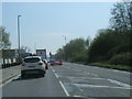
St Andrew's Road, Avonmouth
Kings Weston Lane turns right off the A403. A lot of traffic spends a lot of time here, especially those turning right. Reeds indicate the presence of water close to the road on the left, and indeed it's only three metres from the pavement to the rhyne shown further north in Image
Image: © Derek Harper
Taken: 19 Oct 2016
0.07 miles
5
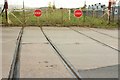
Level crossing gates, King's Weston Lane, Avonmouth
The gates on the other side of the road from Image I don't think the tracks beyond, shown in Image, exist any more.
Image: © Derek Harper
Taken: 19 Oct 2016
0.08 miles
6
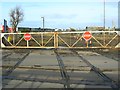
Level crossing gates, King's Weston Lane, Avonmouth
The gates are padlocked shut and it obviously some time since a train passed through them. The lines beyond the gates have been lifted but remain behind the viewpoint as in this image Image
Image: © Brian Robert Marshall
Taken: 25 Nov 2007
0.08 miles
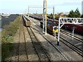
7
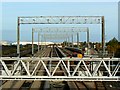
Gantries, St Andrew's Road station, Avonmouth
The station is primarily used for the loading of coal into railway wagons. The higher gantries provide for lighting of the line where trains are formed up. The lower gantry in the foreground carries signals.
Image: © Brian Robert Marshall
Taken: 25 Nov 2007
0.09 miles
8
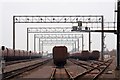
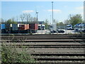
HTA coal wagons in the sidings
The rail yard is operated by DB Schenker. Many of the trains will stop running when Didcot Power Station closes in March 2013.
Image: © Steve Daniels
Taken: 20 Feb 2013
0.10 miles
9
The railway at St Andrew's Road railway station, Avonmouth
This is a view north from the footbridge over the line in the direction of Severn Beach where the line terminates. This part of the line is used primarily with the transport of coal. A locomotive is ticking over here and there are a number of coal wagons standing empty.
Image: © Brian Robert Marshall
Taken: 25 Nov 2007
0.11 miles
10
Disused building, King's Weston Lane, Avonmouth
This area is in a state of transition. The nearby chemical works is soon to close and production has already been scaled back. It seems possible that the building shown here was a gas meter house where incoming gas to fuel the manufacturing processes was metered or governed.
Image: © Brian Robert Marshall
Taken: 25 Nov 2007
0.11 miles