IMAGES TAKEN NEAR TO
Gorham Close, BRISTOL, BS11 0TP
Introduction
This page details the photographs taken nearby to Gorham Close, BS11 0TP by members of the Geograph project.
The Geograph project started in 2005 with the aim of publishing, organising and preserving representative images for every square kilometre of Great Britain, Ireland and the Isle of Man.

There are currently over 7.5m images from over14,400 individuals and you can help contribute to the project by visiting https://www.geograph.org.uk
Image Map
Images are licensed for reuse under creativecommons.org/licenses/by-sa/2.0
Notes
- Clicking on the map will re-center to the selected point.
- The higher the marker number, the further away the image location is from the centre of the postcode.
Image Listing (15 Images Found)
Images are licensed for reuse under creativecommons.org/licenses/by-sa/2.0
Image
Details
Distance
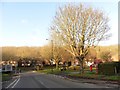
3

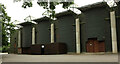
Avon Riding Centre for the Disabled
A track curves past stables at the edge of Moorgrove Wood.
Image: © Derek Harper
Taken: 27 Jun 2021
0.16 miles
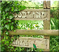
4
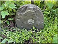
Old Boundary Marker on the B4057 Kings Weston Road
Parish Boundary Marker on the south side of the B4057 Kings Weston Road on the edge of the Blaise Castle Estate. On the 1881 25" OS map this is shown as a boundary stone marking the boundary of an area common to the parishes of Henbury and Westbury on Trym. By 1901 it was entirely in Henbury parish.
Milestone Society National ID: GL_BRIS24pb
Image: © S Kosciow
Taken: 19 Apr 2022
0.17 miles
5
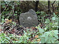
Old Boundary Marker on the B4057 Kings Weston Road
Parish Boundary Marker on the south side of the B4057 Kings Weston Road on the edge of the Blaise Castle Estate. On the 1881 25" OS map this is shown as a boundary stone marking the boundary of an area common to the parishes of Henbury and Westbury on Trym. By 1901 it was entirely in Henbury parish. The stone has suffered more damage since the earlier photo https://www.geograph.org.uk/photo/7152487.
Milestone Society National ID: GL_BRIS24pb
Image: © Roadside Relics
Taken: 28 Sep 2023
0.17 miles
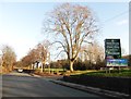
6
Avon Riding Centre for the Disabled
Beside Moorgrove Wood.
Image: © Derek Harper
Taken: 27 Jun 2021
0.18 miles
7
Woodland walk, Moorgrove Wood
Beside a pond at the west edge of the wood.
Image: © Derek Harper
Taken: 27 Jun 2021
0.18 miles
9
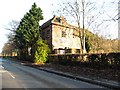
Derelict building on Kings Weston Road
Image: © Roger Cornfoot
Taken: 9 Dec 2019
0.21 miles
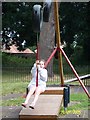
10
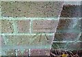
Ordnance Survey Cut Mark
This OS cut mark can be found on the building SE side of Kings Weston Road. It marks a point 56.662m above mean sea level.
Image: © Adrian Dust
Taken: 1 Nov 2021
0.21 miles