IMAGES TAKEN NEAR TO
Little Mead, BRISTOL, BS11 0RH
Introduction
This page details the photographs taken nearby to Little Mead, BS11 0RH by members of the Geograph project.
The Geograph project started in 2005 with the aim of publishing, organising and preserving representative images for every square kilometre of Great Britain, Ireland and the Isle of Man.

There are currently over 7.5m images from over14,400 individuals and you can help contribute to the project by visiting https://www.geograph.org.uk
Image Map
Images are licensed for reuse under creativecommons.org/licenses/by-sa/2.0
Notes
- Clicking on the map will re-center to the selected point.
- The higher the marker number, the further away the image location is from the centre of the postcode.
Image Listing (9 Images Found)
Images are licensed for reuse under creativecommons.org/licenses/by-sa/2.0
Image
Details
Distance
1
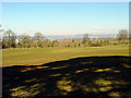
View across the fields towards the River Severn
Looking north across the field, towards the River Severn, the Second Severn Crossing can just be seen in the distance.
Image: © Linda Bailey
Taken: 2 Mar 2006
0.08 miles
2
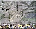
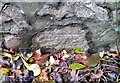
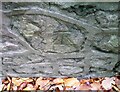
Ordnance Survey Cut Mark
This OS cut mark can be found on the wall NW side of Kings Weston Road. It marks a point 60.771m above mean sea level.
Image: © Adrian Dust
Taken: 1 Nov 2021
0.12 miles
3
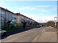
Broadlands Drive, Lawrence Weston
Looking south-west along Broadlands Drive
Image: © Linda Bailey
Taken: 2 Mar 2006
0.13 miles
4
Ordnance Survey Cut Mark
This OS cut mark can be found on the wall NW side of Kings Weston Road. It marks a point 63.990m above mean sea level.
Image: © Adrian Dust
Taken: 1 Nov 2021
0.18 miles
5
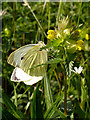
Large White Butterfly on Hay Rattle
Growing in the grass meadow on Kings Weston Hill. Apparently the common name of Hay Rattle (Rhinanthus minor) refers to the noise made by the dry seed case when it is time to harvest the hay. It is also known as Yellow Rattle.
View of the grassland Image
Image: © Linda Bailey
Taken: 29 May 2006
0.21 miles
6
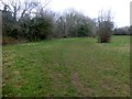
Kings Weston Hill
Took path through woods from Southside Close. Several possible tops in grassland and in woods, then bagged the lower and well hidden trig point.
Name: Kings Weston Hill
Hill number: 17446
Height: 97m / 318ft
Parent (Ma/M): 2869 Cleeve Hill
Section: 39: Central and Eastern England
County/UA: Bristol (UA)
Class: Tump (0-99m)
Grid ref: ST548778 (est)
Drop: 57m
Col: 40m ST559794
Image: © Rude Health
Taken: 26 Mar 2015
0.22 miles
7
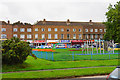
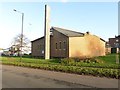
Row of shops in Lawrence Weston
As with many suburbs, the row of shops has a high proportion of food outlets.
Image: © Bill Boaden
Taken: 27 Sep 2017
0.22 miles
8
Ordnance Survey Cut Mark
This OS cut mark can be found on the wall SE side of Kings Weston Road. It marks a point 57.833m above mean sea level.
Image: © Adrian Dust
Taken: 1 Nov 2021
0.23 miles