IMAGES TAKEN NEAR TO
Long Cross, BRISTOL, BS11 0LZ
Introduction
This page details the photographs taken nearby to Long Cross, BS11 0LZ by members of the Geograph project.
The Geograph project started in 2005 with the aim of publishing, organising and preserving representative images for every square kilometre of Great Britain, Ireland and the Isle of Man.

There are currently over 7.5m images from over14,400 individuals and you can help contribute to the project by visiting https://www.geograph.org.uk
Image Map (Loading...)


Getting Data...Please wait
Leaflet Map data © OpenStreetMap
Images are licensed for reuse under creativecommons.org/licenses/by-sa/2.0
Notes
- Clicking on the map will re-center to the selected point.
- The higher the marker number, the further away the image location is from the centre of the postcode.
Image Listing (19 Images Found)
Images are licensed for reuse under creativecommons.org/licenses/by-sa/2.0
Image
Details
Distance
1
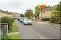
Ridingleaze, Lawrence Weston
From the junction with Broadlands Drive. On the right is the Ann Coleman Centre, the day unit of the Avon Autistic Foundation.
Image: © Derek Harper
Taken: 19 Oct 2016
0.11 miles
2
Church of our lady of the rosary, Kings Weston
Image: © Roger Cornfoot
Taken: 9 Dec 2019
0.13 miles
3
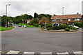
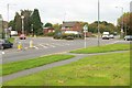
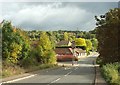
Long Cross roundabout
An important crossroads in this residential area.
Image: © Bill Boaden
Taken: 27 Sep 2017
0.14 miles
4
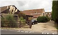
Campbell Farm, Lawrence Weston
On the right can be seen the former farmhouse, now divided into five flats. It is listed and described at https://www.historicengland.org.uk/listing/the-list/list-entry/1209715 . The other farm buildings have also been converted.
Image: © Derek Harper
Taken: 19 Oct 2016
0.14 miles
5
Roundabout, Lawrence Weston
In the very northern corner of the square. On the immediate left is Kings Weston Lane, continuing straight across Long Cross, the main route through Lawrence Weston.
Image: © Derek Harper
Taken: 19 Oct 2016
0.14 miles
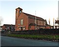
6
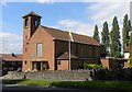
Our Lady of the Rosary Church
A Roman Catholic Church on Kings Weston Lane.
Image: © Colin Bews
Taken: 26 Jul 2011
0.15 miles
7
Kings Weston Lane
Leading towards Cabot Park and the Avonmouth employment area.
Image: © Bill Boaden
Taken: 27 Sep 2017
0.15 miles
8
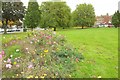
Ridingleaze Green Space, Lawrence Weston
The brief sunny spell has long since ended, and I'm walking with difficulty having done my back in, but this explosion of wild flowers that has been planted on the green between Long Cross (left) and Ridingleaze cheered me up.
Image: © Derek Harper
Taken: 19 Oct 2016
0.16 miles
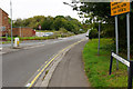
9
Traffic calming, Lawrence Weston
King's Weston Lane enters Lawrence Weston here. Just past the pinch point on the left are converted farm buildings at the former Campbell Farm.
Image: © Derek Harper
Taken: 19 Oct 2016
0.18 miles
10
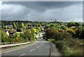
King's Weston Lane approaching Lawrence Weston
Dropping down from the bridge over the motorway lanes shown in Image
Image: © Derek Harper
Taken: 19 Oct 2016
0.19 miles