IMAGES TAKEN NEAR TO
Penpole Avenue, BRISTOL, BS11 0DY
Introduction
This page details the photographs taken nearby to Penpole Avenue, BS11 0DY by members of the Geograph project.
The Geograph project started in 2005 with the aim of publishing, organising and preserving representative images for every square kilometre of Great Britain, Ireland and the Isle of Man.

There are currently over 7.5m images from over14,400 individuals and you can help contribute to the project by visiting https://www.geograph.org.uk
Image Map
Images are licensed for reuse under creativecommons.org/licenses/by-sa/2.0
Notes
- Clicking on the map will re-center to the selected point.
- The higher the marker number, the further away the image location is from the centre of the postcode.
Image Listing (110 Images Found)
Images are licensed for reuse under creativecommons.org/licenses/by-sa/2.0
Image
Details
Distance
1
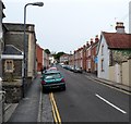
Penpole Avenue, Shirehampton, Bristol
Viewed from the High Street end.
Image: © Jaggery
Taken: 23 Jun 2012
0.01 miles
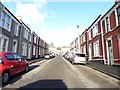
3
Penpole Avenue, Shirehampton
Looking down Penpole Avenue towards Shirehampton High Street with land to the south of the River Avon stretched away in the distance.
Image: © Stephen McKay
Taken: 10 Nov 2010
0.02 miles
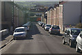
4
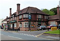
The George Inn, Shirehampton
A substantial-looking pub on Shirehampton's High Street.
Image: © Stephen McKay
Taken: 10 Nov 2010
0.04 miles
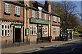
5
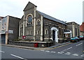
Shirehampton Methodist Church, Bristol
Located on the corner of High Street and Penpole Avenue, Shirehampton.
Image: © Jaggery
Taken: 23 Jun 2012
0.04 miles
7
Shirehampton Methodist church
The church started as a Wesleyan place of worship in the nineteenth century, with a Sunday school being added behind it in following years.
Image: © Neil Owen
Taken: 6 Feb 2023
0.05 miles
8
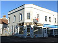
The state of the Estate Agents
This shop on the High Street bears some lovely floral murals, as befitting of a former flower seller's place. However, delving deeper reveals that previously it has been a nail and spa premises, and prior to that was actually a branch of Taylors estate agents! Ironically, the shop next door is now a rival's. Such is the fast-changing face of the High Street these days.
Image: © Neil Owen
Taken: 6 Feb 2023
0.05 miles
9
The George Inn, Shirehampton, Bristol
Large pub located at 4-6 High Street. The old George Inn on this site was built c1760, and named to celebrate the accession of King George III in October 1760.
Image: © Jaggery
Taken: 23 Jun 2012
0.05 miles
10
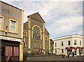
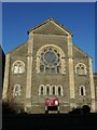
Methodist Church, Shirehampton
Seen from the other direction in Image A Wesleyan chapel is shown here on an 1883 map.
Image: © Derek Harper
Taken: 29 Mar 2014
0.05 miles