IMAGES TAKEN NEAR TO
Pen Park Road, BRISTOL, BS10 6BU
Introduction
This page details the photographs taken nearby to Pen Park Road, BS10 6BU by members of the Geograph project.
The Geograph project started in 2005 with the aim of publishing, organising and preserving representative images for every square kilometre of Great Britain, Ireland and the Isle of Man.

There are currently over 7.5m images from over14,400 individuals and you can help contribute to the project by visiting https://www.geograph.org.uk
Image Map
Images are licensed for reuse under creativecommons.org/licenses/by-sa/2.0
Notes
- Clicking on the map will re-center to the selected point.
- The higher the marker number, the further away the image location is from the centre of the postcode.
Image Listing (34 Images Found)
Images are licensed for reuse under creativecommons.org/licenses/by-sa/2.0
Image
Details
Distance
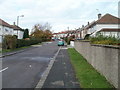
2
Easedale Close, Southmead, Bristol
Viewed from Ravenglass Crescent.
Image: © Jaggery
Taken: 6 Nov 2010
0.09 miles
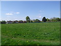
3
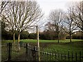
Pen Park, Southmead
Footpath BCC/46/30 leaves Pen Park Road through the gate, although the mapped line of it doesn't correspond to the paved path. Pen Park Hole, a notable underground cavern http://en.wikipedia.org/wiki/Pen_Park_Hole , is screened by the trees in the background.
Image: © Derek Harper
Taken: 22 Feb 2014
0.12 miles
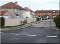
6
Ravenglass Crescent, Southmead, Bristol
Viewed from the corner of Ullswater Road.
Image: © Jaggery
Taken: 6 Nov 2010
0.13 miles
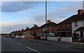
7
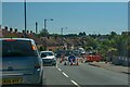
Bristol : Pen Park Road
Looking along Pen Park Road.
Image: © Lewis Clarke
Taken: 10 Aug 2022
0.15 miles
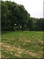
8
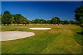
Bristol : Filton Golf Club
Looking across Filton Golf Club.
Image: © Lewis Clarke
Taken: 10 Aug 2022
0.16 miles
9
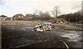
Site of pub, Southmead
The Wayfarer, on Pen Park Road, has been demolished, after closing in May 2011. There are plans to build a Co-op supermarket on the site.
Image: © Derek Harper
Taken: 22 Feb 2014
0.16 miles
10
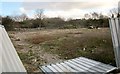
Site of pub, Southmead
Another view across the vacant site shown in Image This shows the area where the Wayfarer pub stood.
Image: © Derek Harper
Taken: 22 Feb 2014
0.16 miles