IMAGES TAKEN NEAR TO
Church Road, SWANLEY, BR8 7FS
Introduction
This page details the photographs taken nearby to Church Road, BR8 7FS by members of the Geograph project.
The Geograph project started in 2005 with the aim of publishing, organising and preserving representative images for every square kilometre of Great Britain, Ireland and the Isle of Man.

There are currently over 7.5m images from over14,400 individuals and you can help contribute to the project by visiting https://www.geograph.org.uk
Image Map
Images are licensed for reuse under creativecommons.org/licenses/by-sa/2.0
Notes
- Clicking on the map will re-center to the selected point.
- The higher the marker number, the further away the image location is from the centre of the postcode.
Image Listing (17 Images Found)
Images are licensed for reuse under creativecommons.org/licenses/by-sa/2.0
Image
Details
Distance
1
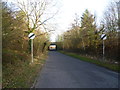
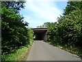
Ship Lane, Swanley passing under the M25
Ship Lane leads from Swanley Village to Sutton at Hone. This is looking towards the latter. The bridge just ahead carries the M25 overhead.
Image: © Marathon
Taken: 13 Jan 2012
0.06 miles

6
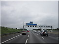
The M25 northbound towards the Dartford Crossing
Image: © Ian S
Taken: 6 Jul 2014
0.11 miles
7
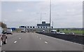
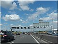
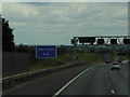
M25 near Swanley Village
6 Miles to next services.
Image: © Julian P Guffogg
Taken: 4 May 2013
0.13 miles