IMAGES TAKEN NEAR TO
Apple Orchard, SWANLEY, BR8 7EL
Introduction
This page details the photographs taken nearby to Apple Orchard, BR8 7EL by members of the Geograph project.
The Geograph project started in 2005 with the aim of publishing, organising and preserving representative images for every square kilometre of Great Britain, Ireland and the Isle of Man.

There are currently over 7.5m images from over14,400 individuals and you can help contribute to the project by visiting https://www.geograph.org.uk
Image Map (Loading...)


Getting Data...Please wait
Leaflet Map data © OpenStreetMap
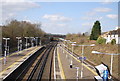
Images are licensed for reuse under creativecommons.org/licenses/by-sa/2.0
Notes
- Clicking on the map will re-center to the selected point.
- The higher the marker number, the further away the image location is from the centre of the postcode.
Image Listing (64 Images Found)
Images are licensed for reuse under creativecommons.org/licenses/by-sa/2.0
Image
Details
Distance
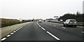
2
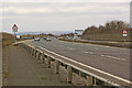
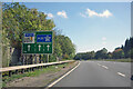
A20 Swanley bypass
Photographed from where the road crosses the Southeastern main railway from London (Victoria) to the Medway towns and beyond. On the left is the private slip road to Bournewood Quarry. In the far distance is Shooters Hill.
Image: © Ian Capper
Taken: 10 Mar 2010
0.07 miles
5
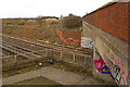
A20 bridge
This graffiti covered bridge is where the A20 Swanley Bypass crosses the Southeastern main railway line from London (Victoria) to the Medway towns and beyond. The subway is for a footpath that runs alongside the railway here, towards Swanley Station. In the background is Bournewood Quarry. On the far left of the photo, at the top of the cutting bank, can be seen an obelisk-type Coal Tax Post (see Image).
Image: © Ian Capper
Taken: 10 Mar 2010
0.07 miles
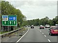
7
A20 eastbound, Swanley
A mile to the start of the M20 at its junction 1.
Image: © Robin Webster
Taken: 27 Sep 2011
0.08 miles
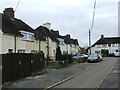
8
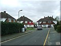
Ladds Way, Swanley
Horizon House is on the horizon.
Image: © Danny P Robinson
Taken: 24 Jul 2012
0.09 miles
9
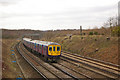
Railway west of Swanley
This is the Southeastern main line from London (Victoria) to the Medway towns and beyond, with First Capital Connect "Thameslink" unit 319 005 on the 11.56 Kentish Town to Sevenoaks service approaching Swanley Station. In the background on the top of the cutting bank can be seen an obelisk-type Coal Tax Post (see Image).
Image: © Ian Capper
Taken: 10 Mar 2010
0.10 miles
10
A20 near Swanley
Private Slip Road to quarry at Windmill Hill Wood.
Image: © Oast House Archive
Taken: 19 Mar 2009
0.11 miles