IMAGES TAKEN NEAR TO
Old Hill, CHISLEHURST, BR7 5LZ
Introduction
This page details the photographs taken nearby to Old Hill, BR7 5LZ by members of the Geograph project.
The Geograph project started in 2005 with the aim of publishing, organising and preserving representative images for every square kilometre of Great Britain, Ireland and the Isle of Man.

There are currently over 7.5m images from over14,400 individuals and you can help contribute to the project by visiting https://www.geograph.org.uk
Image Map
Images are licensed for reuse under creativecommons.org/licenses/by-sa/2.0
Notes
- Clicking on the map will re-center to the selected point.
- The higher the marker number, the further away the image location is from the centre of the postcode.
Image Listing (109 Images Found)
Images are licensed for reuse under creativecommons.org/licenses/by-sa/2.0
Image
Details
Distance
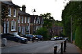
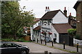
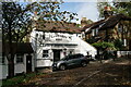
2
The Imperial Arms
Dating from around 1865, this pub was originally called the Windmill Inn. It was renamed following the arrival in Camden Place of the French Imperial family of Napoleon III in 1870. It is locally listed.
Image: © Ian Capper
Taken: 25 Jul 2011
0.05 miles
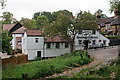
3
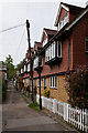
Mill Place
Mill Place links Old Hill and Summer Hill, its name referring to a windmill that once stood nearby, built in 1796 but demolished in 1868. This view is looking towards Old Hill in the background.
On the right is the rear of buildings in Eugenie Mews. These were built on the site of St John's Church, a chapel of ease of St Nicholas' Church built in 1886 and in use until 1933, after which it was used for industrial purposes until demolition in 1998. The name Eugenie Mews commemorates the Empress Eugenie, wife of Napoleon III, who lived at Camden Place following the Emperor's exile from France in 1871. For view of the entrance to the Mews, see Image
Image: © Ian Capper
Taken: 17 May 2012
0.06 miles
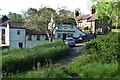
4
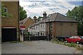
Eugenie Mews
The 1880s cottages on the right are in Mill Place. Eugenie Mews is the name given to the two groups of modern buildings. Those on the left are built on the site of Christ Church School, built in 1889 but closed in 1907 and used for industrial purposes until demolition in 1998, while those beyond are on the site of St John's Church, a chapel of ease of St Nicholas' Church built in 1886 and in use until 1933, after which it too was used for industrial purposes until demolition, also in 1998. The name Eugenie Mews commemorates the Empress Eugenie, wife of Napoleon III, who lived at Camden Place following the Emperor's exile from France in 1871.
Image: © Ian Capper
Taken: 25 Jul 2011
0.06 miles
5
The Ramblers Rest
Located beside the A222, on Summer Hill, Chislehurst.
Image: © Peter Trimming
Taken: 4 Oct 2018
0.07 miles
6
The Ramblers Rest
Located beside the A222, on Summer Hill, Chislehurst.
Image: © Peter Trimming
Taken: 4 Oct 2018
0.07 miles
7
The Ramblers Rest at Chislehurst
Timber-clad pub on a steep hill below the common.
Image: © David Martin
Taken: 22 May 2021
0.08 miles
8
The Ramblers Rest
Located beside the A222, on Summer Hill, Chislehurst.
Image: © Peter Trimming
Taken: 1 Nov 2021
0.08 miles
9
The Ramblers Rest
Located beside the A222, on Summer Hill, Chislehurst.
Image: © Peter Trimming
Taken: 1 Nov 2021
0.08 miles
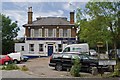
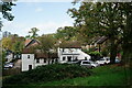
10
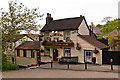
Ramblers Rest
Claimed to date from 1684, although the main building is late 18th century, with a 1970s extension. It was originally called the Miller's Arms, reflecting its position near a windmill that once stood nearby, built in 1796 but demolished in 1868. It is locally listed.
Image: © Ian Capper
Taken: 17 May 2012
0.08 miles