IMAGES TAKEN NEAR TO
Dryland Avenue, ORPINGTON, BR6 9SZ
Introduction
This page details the photographs taken nearby to Dryland Avenue, BR6 9SZ by members of the Geograph project.
The Geograph project started in 2005 with the aim of publishing, organising and preserving representative images for every square kilometre of Great Britain, Ireland and the Isle of Man.

There are currently over 7.5m images from over14,400 individuals and you can help contribute to the project by visiting https://www.geograph.org.uk
Image Map
Images are licensed for reuse under creativecommons.org/licenses/by-sa/2.0
Notes
- Clicking on the map will re-center to the selected point.
- The higher the marker number, the further away the image location is from the centre of the postcode.
Image Listing (58 Images Found)
Images are licensed for reuse under creativecommons.org/licenses/by-sa/2.0
Image
Details
Distance
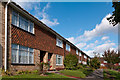
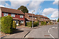
1
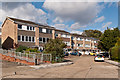
Dryland Avenue
Part of the 1970s Borkwood estate, built on the site of a former school. The railings on the left are on the footpath link to the upper part of the estate.
Image: © Ian Capper
Taken: 16 Oct 2012
0.02 miles
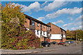
2

Flooding, Borkwood Court
Although Orpington is in a dry valley, the current source of the River Cray being the pond in Priory Gardens at the north end of High Street, high water table levels can lead to flooding further south. After exceptionally high rainfall in early 2014, this is the fate that befell Borkwood Court, a block of flats in Sevenoaks Road.
Image: © Ian Capper
Taken: 27 Mar 2014
0.06 miles
3
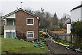
Flooding, Borkwood Court
Although Orpington is in a dry valley, the current source of the River Cray being the pond in Priory Gardens at the north end of High Street, high water table levels can lead to flooding further south. After exceptionally high rainfall in early 2014, this is the fate that befell Borkwood Court, a block of flats in Sevenoaks Road. Here water is being pumped out of the flooded ground floor flats.
Image: © Ian Capper
Taken: 27 Mar 2014
0.06 miles
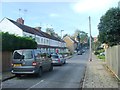
5
Sevenoaks Road
An unusual block of four houses at the junction of Kings Road.
Image: © Ian Capper
Taken: 16 Mar 2010
0.07 miles
6
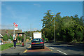
Sevenoaks Road, Cloonmore Avenue bus stop
Served by routes 358, 654, R5, R8, R10 and R11.
Image: © Robin Webster
Taken: 27 Sep 2011
0.08 miles
7
Ryarsh Crescent
Part of the 1970s development of an area of open land between the former Borkwood Park School and Leamington Avenue.
Image: © Ian Capper
Taken: 16 Oct 2012
0.08 miles
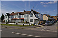
8
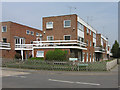
Borkwood Park
1960s flats on Sevenoaks Road.
Image: © Ian Capper
Taken: 21 Apr 2009
0.09 miles
9
Mitchell Road
Part of the early 1980s development of the former St Anne's and St Joseph's Orphanage sites.
Image: © Ian Capper
Taken: 16 Oct 2012
0.10 miles
10
Stapleton Road
Part of the early 1980s development of the former St Ann's and St Joseph's Orphanage sites. In the background is St Anne's Convent.
Image: © Ian Capper
Taken: 16 Oct 2012
0.11 miles