IMAGES TAKEN NEAR TO
Carolyn Drive, ORPINGTON, BR6 9ST
Introduction
This page details the photographs taken nearby to Carolyn Drive, BR6 9ST by members of the Geograph project.
The Geograph project started in 2005 with the aim of publishing, organising and preserving representative images for every square kilometre of Great Britain, Ireland and the Isle of Man.

There are currently over 7.5m images from over14,400 individuals and you can help contribute to the project by visiting https://www.geograph.org.uk
Image Map
Images are licensed for reuse under creativecommons.org/licenses/by-sa/2.0
Notes
- Clicking on the map will re-center to the selected point.
- The higher the marker number, the further away the image location is from the centre of the postcode.
Image Listing (41 Images Found)
Images are licensed for reuse under creativecommons.org/licenses/by-sa/2.0
Image
Details
Distance
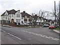
1
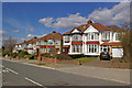
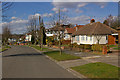
Charterhouse Road
One of a number of roads in southeast Orpington named after public schools. This is a section of Charterhouse Road, between Haileybury Road and Cheltenham Road, with a uniform stretch of semis.
Image: © Ian Capper
Taken: 15 Mar 2010
0.04 miles
2
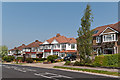
Charterhouse Road
1920s or so housing in one of the "Schools" roads in southeast Orpington.
Image: © Ian Capper
Taken: 22 May 2012
0.04 miles
3
Charterhouse Road
One of a large number of roads in southeasst Orpington named after public schools.
Image: © Ian Capper
Taken: 11 Feb 2009
0.04 miles
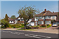
4
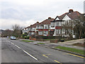
Cheltenham Road
One of a number of roads in southeast Orpington named after public schools, seen here at its junction with Charterhouse Road.
Image: © Ian Capper
Taken: 11 Feb 2009
0.08 miles
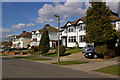
5
Charterhouse Road
1920s or so housing in one of the "Schools" roads in southeast Orpington.
Image: © Ian Capper
Taken: 22 May 2012
0.09 miles
6
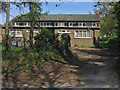
Scout Hut, Goddington Lane
Home of the 3rd Orpington Scouts.
Image: © Ian Capper
Taken: 22 Apr 2009
0.10 miles
7
Sandhurst Road
This is a slight exception to the roads in this part of Orpington, which are generally named after public schools, which Sandhurst is not, even if it is still an educational establishment. This bottom section of the road, with the three semis seen here, has a different character from the upper section - see Image
Image: © Ian Capper
Taken: 15 Mar 2010
0.11 miles
8
Sandhurst Road
This is a slight exception to the roads in this part of Orpington, which are generally named after public schools, which Sandhurst is not, even if it is still an educational establishment. This lower section of the road has a different character from the upper section - see Image
Image: © Ian Capper
Taken: 15 Mar 2010
0.11 miles
9
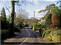
Goddington Lane looking west
See Image for comment on this lane. This picture gives a hint of the once rural nature of the road, with the lack of pavement and the unstraightened route followed.
Image: © Ian Capper
Taken: 30 Jan 2008
0.11 miles