IMAGES TAKEN NEAR TO
Ridgeway Crescent, ORPINGTON, BR6 9QW
Introduction
This page details the photographs taken nearby to Ridgeway Crescent, BR6 9QW by members of the Geograph project.
The Geograph project started in 2005 with the aim of publishing, organising and preserving representative images for every square kilometre of Great Britain, Ireland and the Isle of Man.

There are currently over 7.5m images from over14,400 individuals and you can help contribute to the project by visiting https://www.geograph.org.uk
Image Map
Images are licensed for reuse under creativecommons.org/licenses/by-sa/2.0
Notes
- Clicking on the map will re-center to the selected point.
- The higher the marker number, the further away the image location is from the centre of the postcode.
Image Listing (58 Images Found)
Images are licensed for reuse under creativecommons.org/licenses/by-sa/2.0
Image
Details
Distance
1
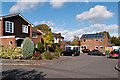
Benedict Close
Part of the early 1980s development of the former St Anne's and St Joseph's Orphanage sites.
Image: © Ian Capper
Taken: 16 Oct 2012
0.04 miles
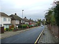
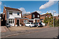
2
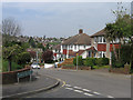
Ridgeway Crescent
Bungalows on the left, "chalet" style houses on the right. This section of the road was developed in the 1930s. Other examples of the chalet style, built by the builder William Brise are in nearby Newstead Avenue (see Image) and in Willett Way, Petts Wood (see Image).
Image: © Ian Capper
Taken: 21 Apr 2009
0.05 miles
3
Stephen Close
Part of the early 1980s development of the former St Anne's and St Joseph's Orphanage sites.
Image: © Ian Capper
Taken: 16 Oct 2012
0.06 miles
4
Benedict Close
Part of the early 1980s development of the former St Anne's and St Joseph's Orphanage sites.
Image: © Ian Capper
Taken: 16 Oct 2012
0.06 miles
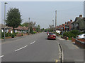
5
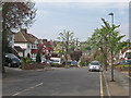
Southcroft Road
1930s road running between Ridgeway Crescent and Tubbenden Lane.
Image: © Ian Capper
Taken: 21 Apr 2009
0.06 miles
6
Marcellina Way
Part of the early 1980s development of the former St Anne's and St Joseph's Orphanage sites. The name commemorates Mother Marcellina Fallon, who was one of the Sisters of Mercy connected with the St Anne's Orphanage.
Image: © Ian Capper
Taken: 16 Oct 2012
0.07 miles
7
Stapleton Road
Part of the early 1980s development of the former St Anne's and St Joseph's Orphanage sites.
Image: © Ian Capper
Taken: 16 Oct 2012
0.10 miles
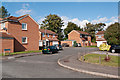
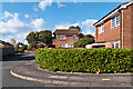
8
Ridgeway Crescent
Part of the postwar development south of Tubbenden Lane.
Image: © Ian Capper
Taken: 21 Apr 2009
0.11 miles
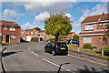
9
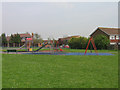
Leamington Avenue Playground
Despite its name, this playground is accessed from Southfleet Road. The reason for the apparent inconsistency is that the open space in which it is situated lies behind the gardens of houses in Leamington Avenue, and presumably existed as such before the Southfleet Road estate (in which the houses in the background are situated) was built.
Image: © Ian Capper
Taken: 21 Apr 2009
0.11 miles